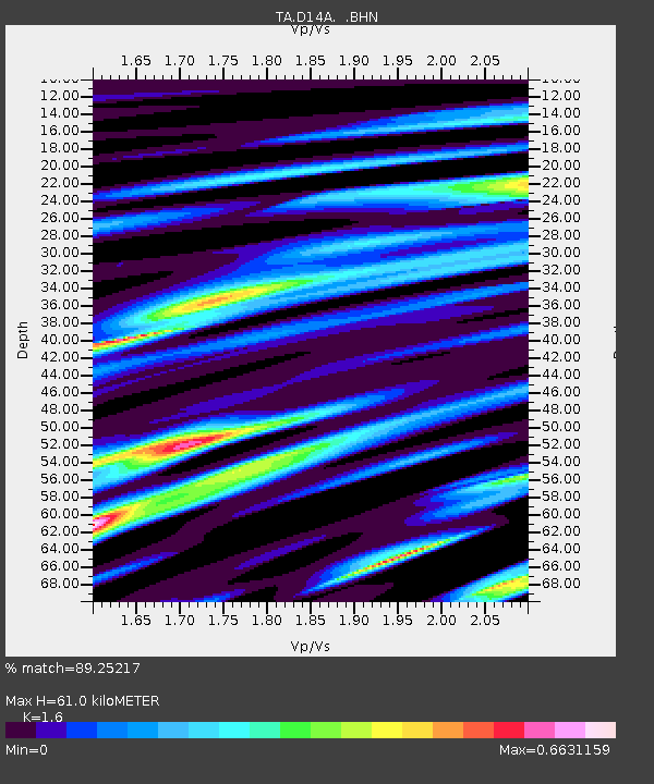
D14A Greenough, MT, USA - Earthquake Result Viewer
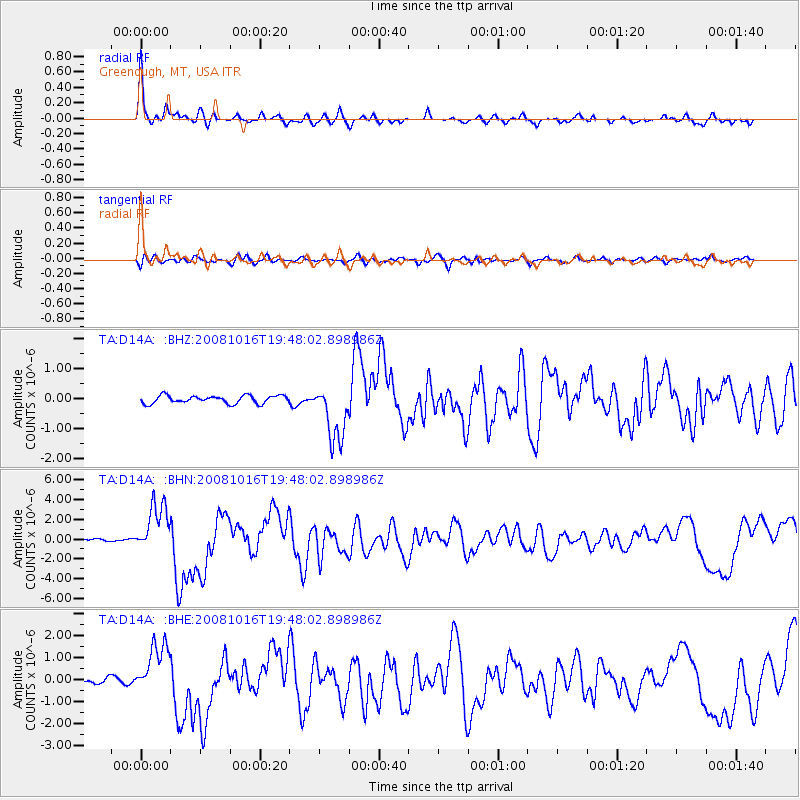
Earthquake location: Near Coast Of Chiapas, Mexico
Earthquake latitude/longitude: 14.4/-92.4
Earthquake time(UTC): 2008/10/16 (290) 19:41:25 GMT
Earthquake Depth: 24 km
Earthquake Magnitude: 6.1 MB, 6.6 MS, 6.7 MW, 6.6 MW
Earthquake Catalog/Contributor: WHDF/NEIC
Network: TA USArray Transportable Network (new EarthScope stations)
Station: D14A Greenough, MT, USA
Lat/Lon: 47.08 N/113.51 W
Elevation: 1444 m
Distance: 37.0 deg
Az: 335.842 deg
Baz: 144.535 deg
Ray Param: 0.07631972
Estimated Moho Depth: 61.0 km
Estimated Crust Vp/Vs: 1.60
Assumed Crust Vp: 6.353 km/s
Estimated Crust Vs: 3.971 km/s
Estimated Crust Poisson's Ratio: 0.18
Radial Match: 89.25217 %
Radial Bump: 348
Transverse Match: 67.141594 %
Transverse Bump: 400
SOD ConfigId: 2556
Insert Time: 2010-03-06 21:33:04.129 +0000
GWidth: 2.5
Max Bumps: 400
Tol: 0.001

Signal To Noise

ChannelStoNSTALTA
TA:D14A: :BHN:20081016T19:48:02.898986Z9.80608752.520091E-62.569925E-7
TA:D14A: :BHE:20081016T19:48:02.898986Z10.840631.1835259E-61.0917502E-7
TA:D14A: :BHZ:20081016T19:48:02.898986Z7.47902159.746593E-71.303191E-7
Arrivals
Ps6.2 SECOND
PpPs23 SECOND
PsPs/PpSs29 SECOND