You are here: Home > Network List > TA - USArray Transportable Network (new EarthScope stations) Stations List
> Station J18K Innoko River, AK, USA > Earthquake Result Viewer
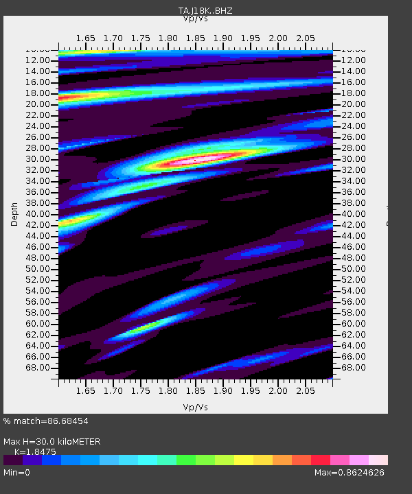
J18K Innoko River, AK, USA - Earthquake Result Viewer
| Earthquake location: |
Taiwan |
| Earthquake latitude/longitude: |
24.0/121.7 |
| Earthquake time(UTC): |
2019/04/18 (108) 05:01:06 GMT |
| Earthquake Depth: |
20 km |
| Earthquake Magnitude: |
6.1 Mww |
| Earthquake Catalog/Contributor: |
NEIC PDE/us |
|
| Network: |
TA USArray Transportable Network (new EarthScope stations) |
| Station: |
J18K Innoko River, AK, USA |
| Lat/Lon: |
63.47 N/156.72 W |
| Elevation: |
506 m |
|
| Distance: |
65.1 deg |
| Az: |
29.335 deg |
| Baz: |
273.925 deg |
| Ray Param: |
0.05848272 |
| Estimated Moho Depth: |
30.0 km |
| Estimated Crust Vp/Vs: |
1.85 |
| Assumed Crust Vp: |
6.182 km/s |
| Estimated Crust Vs: |
3.346 km/s |
| Estimated Crust Poisson's Ratio: |
0.29 |
|
| Radial Match: |
86.68454 % |
| Radial Bump: |
400 |
| Transverse Match: |
71.68703 % |
| Transverse Bump: |
400 |
| SOD ConfigId: |
13570011 |
| Insert Time: |
2019-05-02 23:13:54.446 +0000 |
| GWidth: |
2.5 |
| Max Bumps: |
400 |
| Tol: |
0.001 |
|

Signal To Noise
| Channel | StoN | STA | LTA |
| TA:J18K: :BHZ:20190418T05:11:14.37497Z | 18.501661 | 2.6806367E-6 | 1.4488627E-7 |
| TA:J18K: :BHN:20190418T05:11:14.37497Z | 1.2574891 | 1.8710406E-7 | 1.487918E-7 |
| TA:J18K: :BHE:20190418T05:11:14.37497Z | 6.286297 | 8.927239E-7 | 1.4201109E-7 |
| Arrivals |
| Ps | 4.3 SECOND |
| PpPs | 13 SECOND |
| PsPs/PpSs | 18 SECOND |


