You are here: Home > Network List > TA - USArray Transportable Network (new EarthScope stations) Stations List
> Station M11K Mekoryuk, AK, USA > Earthquake Result Viewer
M11K Mekoryuk, AK, USA - Earthquake Result Viewer
| Earthquake location: |
Taiwan |
| Earthquake latitude/longitude: |
24.0/121.7 |
| Earthquake time(UTC): |
2019/04/18 (108) 05:01:06 GMT |
| Earthquake Depth: |
20 km |
| Earthquake Magnitude: |
6.1 Mww |
| Earthquake Catalog/Contributor: |
NEIC PDE/us |
|
| Network: |
TA USArray Transportable Network (new EarthScope stations) |
| Station: |
M11K Mekoryuk, AK, USA |
| Lat/Lon: |
60.38 N/166.20 W |
| Elevation: |
3.0 m |
|
| Distance: |
60.6 deg |
| Az: |
32.845 deg |
| Baz: |
267.164 deg |
| Ray Param: |
0.061383933 |
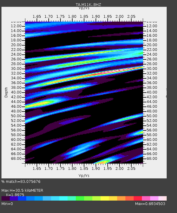
| Estimated Moho Depth: |
30.5 km |
| Estimated Crust Vp/Vs: |
2.00 |
| Assumed Crust Vp: |
6.134 km/s |
| Estimated Crust Vs: |
3.071 km/s |
| Estimated Crust Poisson's Ratio: |
0.33 |
|
| Radial Match: |
83.075676 % |
| Radial Bump: |
400 |
| Transverse Match: |
68.68573 % |
| Transverse Bump: |
400 |
| SOD ConfigId: |
13570011 |
| Insert Time: |
2019-05-02 23:14:08.706 +0000 |
| GWidth: |
2.5 |
| Max Bumps: |
400 |
| Tol: |
0.001 |
|

Signal To Noise
| Channel | StoN | STA | LTA |
| TA:M11K: :BHZ:20190418T05:10:44.774995Z | 8.770534 | 2.6156779E-6 | 2.9823474E-7 |
| TA:M11K: :BHN:20190418T05:10:44.774995Z | 0.6208506 | 2.0364466E-7 | 3.2800912E-7 |
| TA:M11K: :BHE:20190418T05:10:44.774995Z | 4.887866 | 1.3101698E-6 | 2.6804537E-7 |
| Arrivals |
| Ps | 5.1 SECOND |
| PpPs | 14 SECOND |
| PsPs/PpSs | 20 SECOND |


