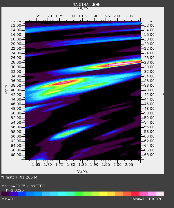
D14A Greenough, MT, USA - Earthquake Result Viewer
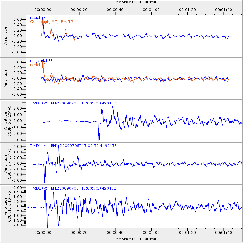
Earthquake location: Rat Islands, Aleutian Islands
Earthquake latitude/longitude: 50.4/177.0
Earthquake time(UTC): 2009/07/06 (187) 14:53:12 GMT
Earthquake Depth: 22 km
Earthquake Magnitude: 6.0 MB, 5.8 MS, 6.1 MW, 6.0 MW
Earthquake Catalog/Contributor: WHDF/NEIC
Network: TA USArray Transportable Network (new EarthScope stations)
Station: D14A Greenough, MT, USA
Lat/Lon: 47.08 N/113.51 W
Elevation: 1444 m
Distance: 44.4 deg
Az: 66.16 deg
Baz: 301.14 deg
Ray Param: 0.07189934
Estimated Moho Depth: 28.25 km
Estimated Crust Vp/Vs: 2.02
Assumed Crust Vp: 6.353 km/s
Estimated Crust Vs: 3.141 km/s
Estimated Crust Poisson's Ratio: 0.34
Radial Match: 91.26544 %
Radial Bump: 381
Transverse Match: 86.814644 %
Transverse Bump: 400
SOD ConfigId: 2648
Insert Time: 2010-03-06 21:33:35.269 +0000
GWidth: 2.5
Max Bumps: 400
Tol: 0.001

Signal To Noise

ChannelStoNSTALTA
TA:D14A: :BHN:20090706T15:00:50.449015Z30.8115672.2874617E-67.4240354E-8
TA:D14A: :BHE:20090706T15:00:50.449015Z11.2284098.51796E-77.586079E-8
TA:D14A: :BHZ:20090706T15:00:50.449015Z13.852121.1060393E-67.984622E-8
Arrivals
Ps4.8 SECOND
PpPs13 SECOND
PsPs/PpSs18 SECOND