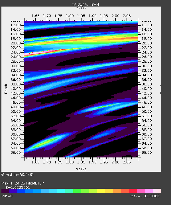
D14A Greenough, MT, USA - Earthquake Result Viewer
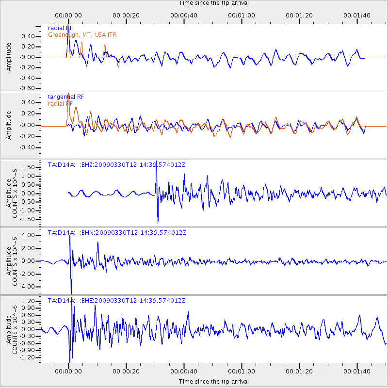
Earthquake location: Andreanof Islands, Aleutian Is.
Earthquake latitude/longitude: 51.5/-178.3
Earthquake time(UTC): 2009/03/30 (089) 12:07:28 GMT
Earthquake Depth: 31 km
Earthquake Magnitude: 6.0 MB, 5.5 MS, 5.7 MW, 5.7 MW
Earthquake Catalog/Contributor: WHDF/NEIC
Network: TA USArray Transportable Network (new EarthScope stations)
Station: D14A Greenough, MT, USA
Lat/Lon: 47.08 N/113.51 W
Elevation: 1444 m
Distance: 41.2 deg
Az: 69.726 deg
Baz: 300.983 deg
Ray Param: 0.073868215
Estimated Moho Depth: 24.25 km
Estimated Crust Vp/Vs: 1.62
Assumed Crust Vp: 6.353 km/s
Estimated Crust Vs: 3.916 km/s
Estimated Crust Poisson's Ratio: 0.19
Radial Match: 80.4491 %
Radial Bump: 400
Transverse Match: 63.536713 %
Transverse Bump: 400
SOD ConfigId: 2658
Insert Time: 2010-03-06 21:33:43.420 +0000
GWidth: 2.5
Max Bumps: 400
Tol: 0.001

Signal To Noise

ChannelStoNSTALTA
TA:D14A: :BHN:20090330T12:14:39.574012Z8.7858531.469291E-61.6723374E-7
TA:D14A: :BHE:20090330T12:14:39.574012Z4.32760145.4864137E-71.2677725E-7
TA:D14A: :BHZ:20090330T12:14:39.574012Z5.26725245.775637E-71.0965179E-7
Arrivals
Ps2.6 SECOND
PpPs9.3 SECOND
PsPs/PpSs12 SECOND