You are here: Home > Network List > TA - USArray Transportable Network (new EarthScope stations) Stations List
> Station D14A Greenough, MT, USA > Earthquake Result Viewer
D14A Greenough, MT, USA - Earthquake Result Viewer
| Earthquake location: |
South Of Mariana Islands |
| Earthquake latitude/longitude: |
10.5/145.7 |
| Earthquake time(UTC): |
2007/09/30 (273) 02:08:30 GMT |
| Earthquake Depth: |
14 km |
| Earthquake Magnitude: |
6.4 MB, 7.1 MS, 6.9 MW, 6.9 MW |
| Earthquake Catalog/Contributor: |
WHDF/NEIC |
|
| Network: |
TA USArray Transportable Network (new EarthScope stations) |
| Station: |
D14A Greenough, MT, USA |
| Lat/Lon: |
47.08 N/113.51 W |
| Elevation: |
1444 m |
|
| Distance: |
89.7 deg |
| Az: |
42.173 deg |
| Baz: |
284.919 deg |
| Ray Param: |
0.04172818 |
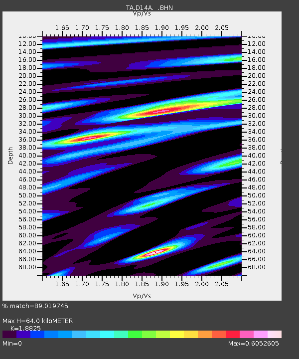
| Estimated Moho Depth: |
64.0 km |
| Estimated Crust Vp/Vs: |
1.88 |
| Assumed Crust Vp: |
6.353 km/s |
| Estimated Crust Vs: |
3.375 km/s |
| Estimated Crust Poisson's Ratio: |
0.30 |
|
| Radial Match: |
89.019745 % |
| Radial Bump: |
400 |
| Transverse Match: |
75.770164 % |
| Transverse Bump: |
400 |
| SOD ConfigId: |
2564 |
| Insert Time: |
2010-03-06 21:34:01.141 +0000 |
| GWidth: |
2.5 |
| Max Bumps: |
400 |
| Tol: |
0.001 |
|

Signal To Noise
| Channel | StoN | STA | LTA |
| TA:D14A: :BHN:20070930T02:20:55.950029Z | 0.9872098 | 1.5245422E-7 | 1.5442942E-7 |
| TA:D14A: :BHE:20070930T02:20:55.950029Z | 1.9674505 | 1.91694E-7 | 9.743269E-8 |
| TA:D14A: :BHZ:20070930T02:20:55.950029Z | 2.9206235 | 2.8250724E-7 | 9.672839E-8 |
| Arrivals |
| Ps | 9.1 SECOND |
| PpPs | 28 SECOND |
| PsPs/PpSs | 38 SECOND |


