You are here: Home > Network List > AU - Australian Seismological Centre Stations List
> Station MTN Manton Dam, Northern Territory > Earthquake Result Viewer
MTN Manton Dam, Northern Territory - Earthquake Result Viewer
| Earthquake location: |
Western Indian-Antarctic Ridge |
| Earthquake latitude/longitude: |
-51.1/139.5 |
| Earthquake time(UTC): |
2019/04/18 (108) 14:46:01 GMT |
| Earthquake Depth: |
10 km |
| Earthquake Magnitude: |
6.5 Mww |
| Earthquake Catalog/Contributor: |
NEIC PDE/us |
|
| Network: |
AU Australian Seismological Centre |
| Station: |
MTN Manton Dam, Northern Territory |
| Lat/Lon: |
12.84 S/131.13 E |
| Elevation: |
137 m |
|
| Distance: |
38.7 deg |
| Az: |
346.898 deg |
| Baz: |
171.565 deg |
| Ray Param: |
0.07540496 |
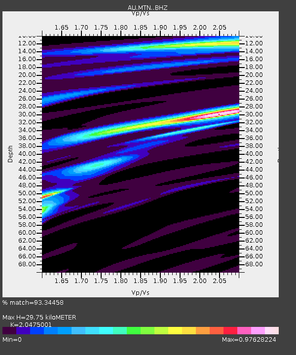
| Estimated Moho Depth: |
29.75 km |
| Estimated Crust Vp/Vs: |
2.05 |
| Assumed Crust Vp: |
6.61 km/s |
| Estimated Crust Vs: |
3.228 km/s |
| Estimated Crust Poisson's Ratio: |
0.34 |
|
| Radial Match: |
93.34458 % |
| Radial Bump: |
204 |
| Transverse Match: |
77.53591 % |
| Transverse Bump: |
400 |
| SOD ConfigId: |
13570011 |
| Insert Time: |
2019-05-02 23:16:38.896 +0000 |
| GWidth: |
2.5 |
| Max Bumps: |
400 |
| Tol: |
0.001 |
|

Signal To Noise
| Channel | StoN | STA | LTA |
| AU:MTN: :BHZ:20190418T14:52:55.118987Z | 3.0356674 | 5.9627706E-7 | 1.9642371E-7 |
| AU:MTN: :BHN:20190418T14:52:55.118987Z | 2.1913326 | 4.6610901E-7 | 2.1270573E-7 |
| AU:MTN: :BHE:20190418T14:52:55.118987Z | 1.8847613 | 1.9517866E-7 | 1.0355617E-7 |
| Arrivals |
| Ps | 5.0 SECOND |
| PpPs | 13 SECOND |
| PsPs/PpSs | 18 SECOND |


