You are here: Home > Network List > TS - TERRAscope (Southern California Seismic Network) Stations List
> Station DGR Domenigoni Valley Reservior, California, USA > Earthquake Result Viewer
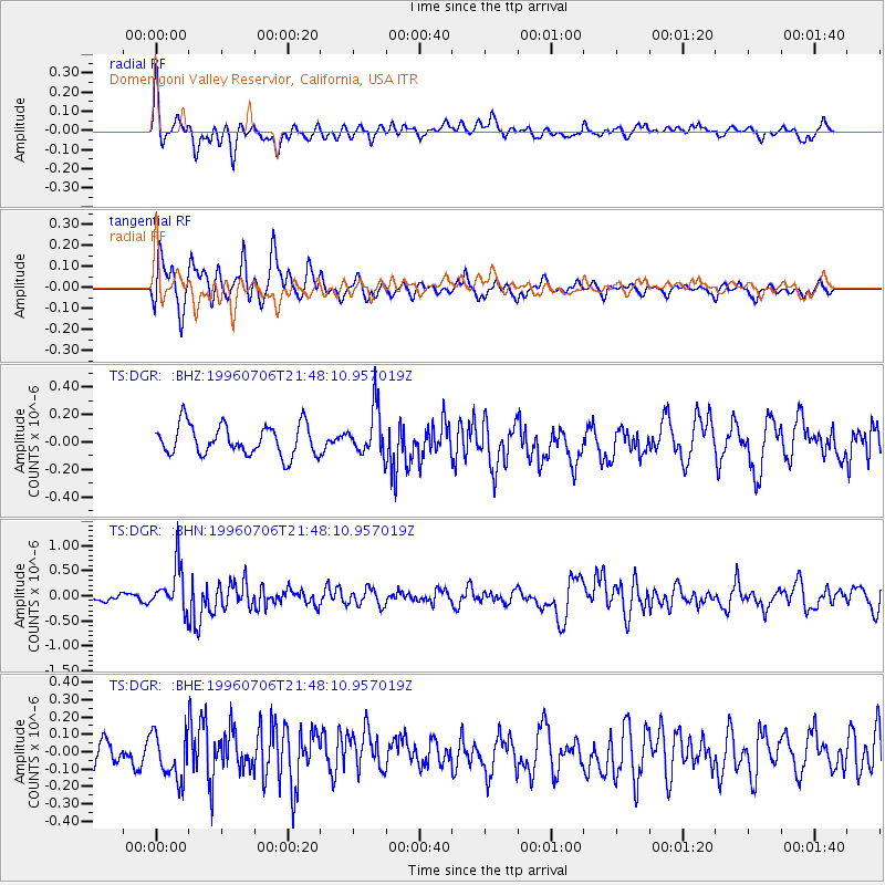
DGR Domenigoni Valley Reservior, California, USA - Earthquake Result Viewer
*The percent match for this event was below the threshold and hence no stack was calculated.
| Earthquake location: |
Mariana Islands Region |
| Earthquake latitude/longitude: |
22.0/142.8 |
| Earthquake time(UTC): |
1996/07/06 (188) 21:36:28 GMT |
| Earthquake Depth: |
241 km |
| Earthquake Magnitude: |
5.8 MB, 6.3 UNKNOWN, 6.2 MW |
| Earthquake Catalog/Contributor: |
WHDF/NEIC |
|
| Network: |
TS TERRAscope (Southern California Seismic Network) |
| Station: |
DGR Domenigoni Valley Reservior, California, USA |
| Lat/Lon: |
33.65 N/117.01 W |
| Elevation: |
700 m |
|
| Distance: |
86.1 deg |
| Az: |
55.386 deg |
| Baz: |
293.673 deg |
| Ray Param: |
$rayparam |
*The percent match for this event was below the threshold and hence was not used in the summary stack. |
|
| Radial Match: |
54.786953 % |
| Radial Bump: |
400 |
| Transverse Match: |
76.533066 % |
| Transverse Bump: |
400 |
| SOD ConfigId: |
4480 |
| Insert Time: |
2010-02-26 14:10:47.926 +0000 |
| GWidth: |
2.5 |
| Max Bumps: |
400 |
| Tol: |
0.001 |
|
Signal To Noise
| Channel | StoN | STA | LTA |
| TS:DGR: :BHN:19960706T21:48:10.957019Z | 3.0957558 | 4.5077613E-7 | 1.4561101E-7 |
| TS:DGR: :BHE:19960706T21:48:10.957019Z | 1.1012418 | 1.2828609E-7 | 1.16492195E-7 |
| TS:DGR: :BHZ:19960706T21:48:10.957019Z | 1.5505592 | 1.708653E-7 | 1.10195934E-7 |
| Arrivals |
| Ps | |
| PpPs | |
| PsPs/PpSs | |


