You are here: Home > Network List > TA - USArray Transportable Network (new EarthScope stations) Stations List
> Station D14A Greenough, MT, USA > Earthquake Result Viewer
D14A Greenough, MT, USA - Earthquake Result Viewer
| Earthquake location: |
Vanuatu Islands |
| Earthquake latitude/longitude: |
-15.6/167.7 |
| Earthquake time(UTC): |
2007/08/01 (213) 17:08:51 GMT |
| Earthquake Depth: |
120 km |
| Earthquake Magnitude: |
6.2 MB, 7.2 MW, 7.2 MW |
| Earthquake Catalog/Contributor: |
WHDF/NEIC |
|
| Network: |
TA USArray Transportable Network (new EarthScope stations) |
| Station: |
D14A Greenough, MT, USA |
| Lat/Lon: |
47.08 N/113.51 W |
| Elevation: |
1444 m |
|
| Distance: |
93.9 deg |
| Az: |
42.217 deg |
| Baz: |
251.35 deg |
| Ray Param: |
0.04110095 |
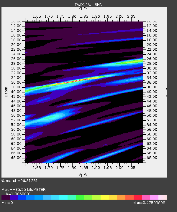
| Estimated Moho Depth: |
35.25 km |
| Estimated Crust Vp/Vs: |
1.81 |
| Assumed Crust Vp: |
6.353 km/s |
| Estimated Crust Vs: |
3.52 km/s |
| Estimated Crust Poisson's Ratio: |
0.28 |
|
| Radial Match: |
96.31251 % |
| Radial Bump: |
268 |
| Transverse Match: |
85.67533 % |
| Transverse Bump: |
400 |
| SOD ConfigId: |
2564 |
| Insert Time: |
2010-03-06 21:34:16.882 +0000 |
| GWidth: |
2.5 |
| Max Bumps: |
400 |
| Tol: |
0.001 |
|

Signal To Noise
| Channel | StoN | STA | LTA |
| TA:D14A: :BHN:20070801T17:21:23.900Z | 1.3222942 | 4.462052E-8 | 3.3744776E-8 |
| TA:D14A: :BHE:20070801T17:21:23.900Z | 5.114342 | 2.1493607E-7 | 4.202614E-8 |
| TA:D14A: :BHZ:20070801T17:21:23.900Z | 8.869469 | 7.023549E-7 | 7.9187934E-8 |
| Arrivals |
| Ps | 4.6 SECOND |
| PpPs | 15 SECOND |
| PsPs/PpSs | 20 SECOND |


