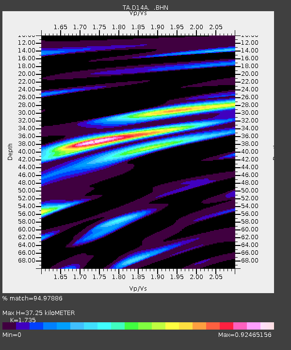
D14A Greenough, MT, USA - Earthquake Result Viewer

Earthquake location: Andreanof Islands, Aleutian Is.
Earthquake latitude/longitude: 51.8/-176.3
Earthquake time(UTC): 2007/07/13 (194) 21:54:43 GMT
Earthquake Depth: 35 km
Earthquake Magnitude: 5.7 MB, 5.6 MS, 6.0 MW, 5.9 MW
Earthquake Catalog/Contributor: WHDF/NEIC
Network: TA USArray Transportable Network (new EarthScope stations)
Station: D14A Greenough, MT, USA
Lat/Lon: 47.08 N/113.51 W
Elevation: 1444 m
Distance: 40.0 deg
Az: 71.126 deg
Baz: 300.788 deg
Ray Param: 0.07460285
Estimated Moho Depth: 37.25 km
Estimated Crust Vp/Vs: 1.74
Assumed Crust Vp: 6.353 km/s
Estimated Crust Vs: 3.662 km/s
Estimated Crust Poisson's Ratio: 0.25
Radial Match: 94.97886 %
Radial Bump: 400
Transverse Match: 85.41981 %
Transverse Bump: 400
SOD ConfigId: 2564
Insert Time: 2010-03-06 21:34:28.916 +0000
GWidth: 2.5
Max Bumps: 400
Tol: 0.001

Signal To Noise

ChannelStoNSTALTA
TA:D14A: :BHN:20070713T22:01:43.724014Z8.8082214.526027E-75.138412E-8
TA:D14A: :BHE:20070713T22:01:43.724014Z12.3657326.2262393E-75.0350753E-8
TA:D14A: :BHZ:20070713T22:01:43.724014Z26.063451.309516E-65.024339E-8
Arrivals
Ps4.6 SECOND
PpPs15 SECOND
PsPs/PpSs20 SECOND