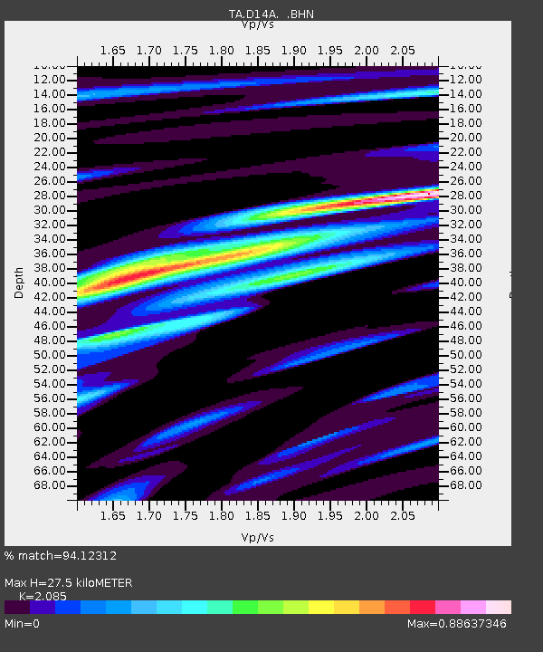
D14A Greenough, MT, USA - Earthquake Result Viewer
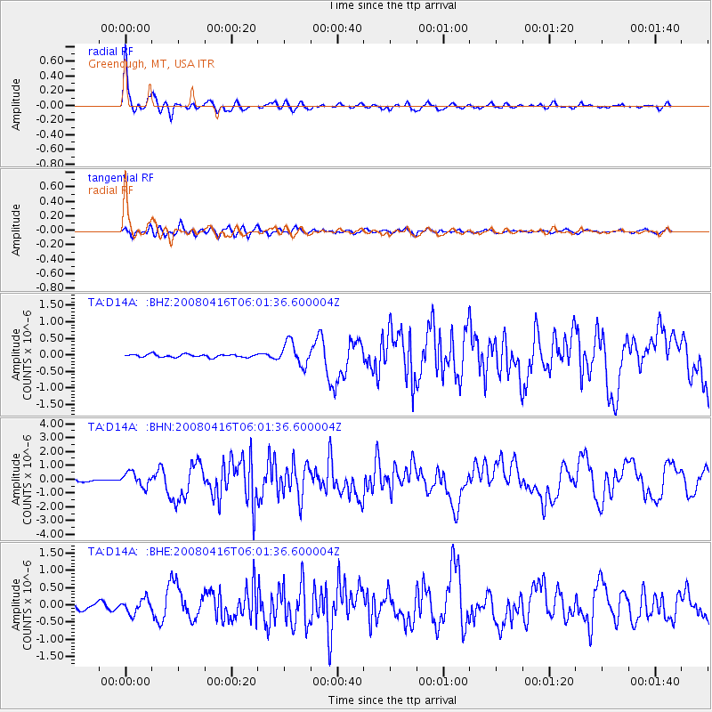
Earthquake location: Andreanof Islands, Aleutian Is.
Earthquake latitude/longitude: 51.9/-179.2
Earthquake time(UTC): 2008/04/16 (107) 05:54:19 GMT
Earthquake Depth: 13 km
Earthquake Magnitude: 6.1 MB, 6.5 MS, 6.6 MW, 6.6 MW
Earthquake Catalog/Contributor: WHDF/NEIC
Network: TA USArray Transportable Network (new EarthScope stations)
Station: D14A Greenough, MT, USA
Lat/Lon: 47.08 N/113.51 W
Elevation: 1444 m
Distance: 41.6 deg
Az: 69.603 deg
Baz: 301.766 deg
Ray Param: 0.07366368
Estimated Moho Depth: 27.5 km
Estimated Crust Vp/Vs: 2.09
Assumed Crust Vp: 6.353 km/s
Estimated Crust Vs: 3.047 km/s
Estimated Crust Poisson's Ratio: 0.35
Radial Match: 94.12312 %
Radial Bump: 372
Transverse Match: 72.764275 %
Transverse Bump: 400
SOD ConfigId: 2504
Insert Time: 2010-03-06 21:34:51.165 +0000
GWidth: 2.5
Max Bumps: 400
Tol: 0.001

Signal To Noise

ChannelStoNSTALTA
TA:D14A: :BHN:20080416T06:01:36.600004Z5.1198485.01944E-79.803885E-8
TA:D14A: :BHE:20080416T06:01:36.600004Z1.63551882.082179E-71.2731E-7
TA:D14A: :BHZ:20080416T06:01:36.600004Z8.0322293.485441E-74.3393193E-8
Arrivals
Ps5.0 SECOND
PpPs13 SECOND
PsPs/PpSs18 SECOND