You are here: Home > Network List > TA - USArray Transportable Network (new EarthScope stations) Stations List
> Station D14A Greenough, MT, USA > Earthquake Result Viewer
D14A Greenough, MT, USA - Earthquake Result Viewer

| Earthquake location: |
South Of Mariana Islands |
| Earthquake latitude/longitude: |
12.5/143.2 |
| Earthquake time(UTC): |
2008/05/09 (130) 21:51:29 GMT |
| Earthquake Depth: |
76 km |
| Earthquake Magnitude: |
6.1 MB, 6.7 MW, 6.7 MW |
| Earthquake Catalog/Contributor: |
WHDF/NEIC |
|
| Network: |
TA USArray Transportable Network (new EarthScope stations) |
| Station: |
D14A Greenough, MT, USA |
| Lat/Lon: |
47.08 N/113.51 W |
| Elevation: |
1444 m |
|
| Distance: |
89.8 deg |
| Az: |
41.686 deg |
| Baz: |
288.139 deg |
| Ray Param: |
0.041705135 |
| Estimated Moho Depth: |
34.0 km |
| Estimated Crust Vp/Vs: |
1.85 |
| Assumed Crust Vp: |
6.353 km/s |
| Estimated Crust Vs: |
3.429 km/s |
| Estimated Crust Poisson's Ratio: |
0.29 |
|
| Radial Match: |
86.704994 % |
| Radial Bump: |
400 |
| Transverse Match: |
68.980415 % |
| Transverse Bump: |
400 |
| SOD ConfigId: |
2504 |
| Insert Time: |
2010-03-06 21:34:55.981 +0000 |
| GWidth: |
2.5 |
| Max Bumps: |
400 |
| Tol: |
0.001 |
|
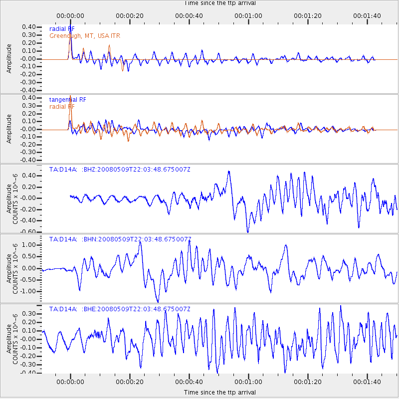
Signal To Noise
| Channel | StoN | STA | LTA |
| TA:D14A: :BHN:20080509T22:03:48.675007Z | 7.2420187 | 3.627304E-7 | 5.0086914E-8 |
| TA:D14A: :BHE:20080509T22:03:48.675007Z | 0.8916678 | 8.645492E-8 | 9.695866E-8 |
| TA:D14A: :BHZ:20080509T22:03:48.675007Z | 2.7987494 | 1.17455166E-7 | 4.1967017E-8 |
| Arrivals |
| Ps | 4.7 SECOND |
| PpPs | 15 SECOND |
| PsPs/PpSs | 20 SECOND |


