You are here: Home > Network List > US - United States National Seismic Network Stations List
> Station EGMT Eagleton, Montana, USA > Earthquake Result Viewer
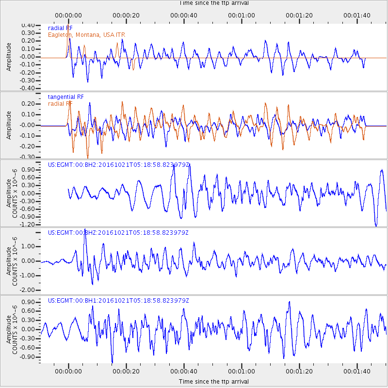
EGMT Eagleton, Montana, USA - Earthquake Result Viewer
*The percent match for this event was below the threshold and hence no stack was calculated.
| Earthquake location: |
Western Honshu, Japan |
| Earthquake latitude/longitude: |
35.4/133.8 |
| Earthquake time(UTC): |
2016/10/21 (295) 05:07:23 GMT |
| Earthquake Depth: |
10 km |
| Earthquake Magnitude: |
6.2 MWW, 6.6 MI |
| Earthquake Catalog/Contributor: |
NEIC PDE/NEIC COMCAT |
|
| Network: |
US United States National Seismic Network |
| Station: |
EGMT Eagleton, Montana, USA |
| Lat/Lon: |
48.02 N/109.75 W |
| Elevation: |
1055 m |
|
| Distance: |
79.5 deg |
| Az: |
37.687 deg |
| Baz: |
311.894 deg |
| Ray Param: |
$rayparam |
*The percent match for this event was below the threshold and hence was not used in the summary stack. |
|
| Radial Match: |
65.40278 % |
| Radial Bump: |
400 |
| Transverse Match: |
57.848835 % |
| Transverse Bump: |
400 |
| SOD ConfigId: |
1815711 |
| Insert Time: |
2016-11-04 05:13:09.919 +0000 |
| GWidth: |
2.5 |
| Max Bumps: |
400 |
| Tol: |
0.001 |
|
Signal To Noise
| Channel | StoN | STA | LTA |
| US:EGMT:00:BHZ:20161021T05:18:58.823979Z | 2.5863225 | 3.888171E-7 | 1.503359E-7 |
| US:EGMT:00:BH1:20161021T05:18:58.823979Z | 1.2634062 | 2.3846457E-7 | 1.8874735E-7 |
| US:EGMT:00:BH2:20161021T05:18:58.823979Z | 1.7739295 | 3.867335E-7 | 2.180095E-7 |
| Arrivals |
| Ps | |
| PpPs | |
| PsPs/PpSs | |


