You are here: Home > Network List > TA - USArray Transportable Network (new EarthScope stations) Stations List
> Station D14A Greenough, MT, USA > Earthquake Result Viewer
D14A Greenough, MT, USA - Earthquake Result Viewer
| Earthquake location: |
Tonga Islands |
| Earthquake latitude/longitude: |
-20.8/-173.3 |
| Earthquake time(UTC): |
2008/06/26 (178) 21:19:15 GMT |
| Earthquake Depth: |
38 km |
| Earthquake Magnitude: |
6.0 MB, 5.8 MS, 6.2 MW, 6.1 MW |
| Earthquake Catalog/Contributor: |
WHDF/NEIC |
|
| Network: |
TA USArray Transportable Network (new EarthScope stations) |
| Station: |
D14A Greenough, MT, USA |
| Lat/Lon: |
47.08 N/113.51 W |
| Elevation: |
1444 m |
|
| Distance: |
86.3 deg |
| Az: |
36.305 deg |
| Baz: |
234.17 deg |
| Ray Param: |
0.044075534 |
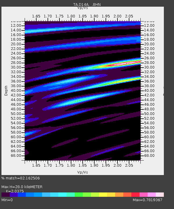
| Estimated Moho Depth: |
28.0 km |
| Estimated Crust Vp/Vs: |
2.04 |
| Assumed Crust Vp: |
6.353 km/s |
| Estimated Crust Vs: |
3.118 km/s |
| Estimated Crust Poisson's Ratio: |
0.34 |
|
| Radial Match: |
82.162506 % |
| Radial Bump: |
400 |
| Transverse Match: |
76.28663 % |
| Transverse Bump: |
400 |
| SOD ConfigId: |
2504 |
| Insert Time: |
2010-03-06 21:35:02.648 +0000 |
| GWidth: |
2.5 |
| Max Bumps: |
400 |
| Tol: |
0.001 |
|

Signal To Noise
| Channel | StoN | STA | LTA |
| TA:D14A: :BHN:20080626T21:31:22.449019Z | 16.809935 | 1.3837655E-6 | 8.2318316E-8 |
| TA:D14A: :BHE:20080626T21:31:22.449019Z | 1.465394 | 1.8760963E-7 | 1.2802676E-7 |
| TA:D14A: :BHZ:20080626T21:31:22.449019Z | 3.9506137 | 4.0277524E-7 | 1.0195258E-7 |
| Arrivals |
| Ps | 4.7 SECOND |
| PpPs | 13 SECOND |
| PsPs/PpSs | 18 SECOND |


