You are here: Home > Network List > TA - USArray Transportable Network (new EarthScope stations) Stations List
> Station D14A Greenough, MT, USA > Earthquake Result Viewer
D14A Greenough, MT, USA - Earthquake Result Viewer
*The percent match for this event was below the threshold and hence no stack was calculated.
| Earthquake location: |
Santiago Del Estero Prov., Arg. |
| Earthquake latitude/longitude: |
-26.7/-63.2 |
| Earthquake time(UTC): |
2008/09/03 (247) 11:25:14 GMT |
| Earthquake Depth: |
570 km |
| Earthquake Magnitude: |
5.9 MB, 6.3 MW, 6.3 MW |
| Earthquake Catalog/Contributor: |
WHDF/NEIC |
|
| Network: |
TA USArray Transportable Network (new EarthScope stations) |
| Station: |
D14A Greenough, MT, USA |
| Lat/Lon: |
47.08 N/113.51 W |
| Elevation: |
1444 m |
|
| Distance: |
86.3 deg |
| Az: |
328.214 deg |
| Baz: |
136.426 deg |
| Ray Param: |
$rayparam |
*The percent match for this event was below the threshold and hence was not used in the summary stack. |
|
| Radial Match: |
70.136604 % |
| Radial Bump: |
400 |
| Transverse Match: |
74.018776 % |
| Transverse Bump: |
372 |
| SOD ConfigId: |
2504 |
| Insert Time: |
2010-03-06 21:35:44.432 +0000 |
| GWidth: |
2.5 |
| Max Bumps: |
400 |
| Tol: |
0.001 |
|
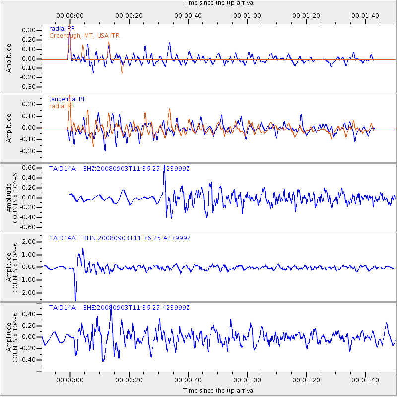
Signal To Noise
| Channel | StoN | STA | LTA |
| TA:D14A: :BHN:20080903T11:36:25.423999Z | 13.599482 | 9.466054E-7 | 6.960599E-8 |
| TA:D14A: :BHE:20080903T11:36:25.423999Z | 1.9848697 | 1.3779075E-7 | 6.9420544E-8 |
| TA:D14A: :BHZ:20080903T11:36:25.423999Z | 3.9099097 | 2.459927E-7 | 6.291519E-8 |
| Arrivals |
| Ps | |
| PpPs | |
| PsPs/PpSs | |


