You are here: Home > Network List > TA - USArray Transportable Network (new EarthScope stations) Stations List
> Station D14A Greenough, MT, USA > Earthquake Result Viewer
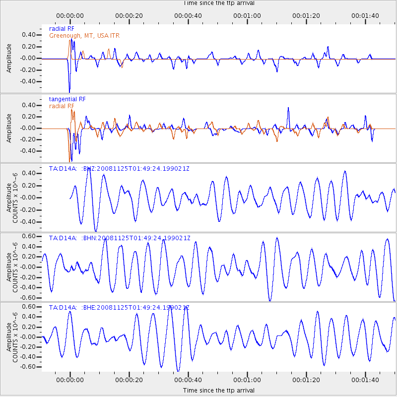
D14A Greenough, MT, USA - Earthquake Result Viewer
*The percent match for this event was below the threshold and hence no stack was calculated.
| Earthquake location: |
Kermadec Islands, New Zealand |
| Earthquake latitude/longitude: |
-30.2/-177.9 |
| Earthquake time(UTC): |
2008/11/25 (330) 01:36:30 GMT |
| Earthquake Depth: |
35 km |
| Earthquake Magnitude: |
5.6 MB, 5.3 MS, 5.6 MW, 5.6 MW |
| Earthquake Catalog/Contributor: |
WHDF/NEIC |
|
| Network: |
TA USArray Transportable Network (new EarthScope stations) |
| Station: |
D14A Greenough, MT, USA |
| Lat/Lon: |
47.08 N/113.51 W |
| Elevation: |
1444 m |
|
| Distance: |
96.3 deg |
| Az: |
38.311 deg |
| Baz: |
231.718 deg |
| Ray Param: |
$rayparam |
*The percent match for this event was below the threshold and hence was not used in the summary stack. |
|
| Radial Match: |
65.35448 % |
| Radial Bump: |
400 |
| Transverse Match: |
53.61986 % |
| Transverse Bump: |
400 |
| SOD ConfigId: |
2658 |
| Insert Time: |
2010-03-06 21:36:06.894 +0000 |
| GWidth: |
2.5 |
| Max Bumps: |
400 |
| Tol: |
0.001 |
|
Signal To Noise
| Channel | StoN | STA | LTA |
| TA:D14A: :BHN:20081125T01:49:24.199021Z | 0.25786653 | 6.007509E-8 | 2.329697E-7 |
| TA:D14A: :BHE:20081125T01:49:24.199021Z | 2.7891347 | 3.0554594E-7 | 1.09548644E-7 |
| TA:D14A: :BHZ:20081125T01:49:24.199021Z | 0.4344391 | 1.0897702E-7 | 2.5084535E-7 |
| Arrivals |
| Ps | |
| PpPs | |
| PsPs/PpSs | |


