You are here: Home > Network List > TA - USArray Transportable Network (new EarthScope stations) Stations List
> Station D14A Greenough, MT, USA > Earthquake Result Viewer
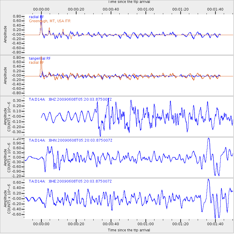
D14A Greenough, MT, USA - Earthquake Result Viewer
*The percent match for this event was below the threshold and hence no stack was calculated.
| Earthquake location: |
Honduras |
| Earthquake latitude/longitude: |
15.8/-86.9 |
| Earthquake time(UTC): |
2009/06/08 (159) 05:13:14 GMT |
| Earthquake Depth: |
10 km |
| Earthquake Magnitude: |
5.5 MB, 4.9 MS, 5.4 MW, 5.4 MW |
| Earthquake Catalog/Contributor: |
WHDF/NEIC |
|
| Network: |
TA USArray Transportable Network (new EarthScope stations) |
| Station: |
D14A Greenough, MT, USA |
| Lat/Lon: |
47.08 N/113.51 W |
| Elevation: |
1444 m |
|
| Distance: |
38.2 deg |
| Az: |
330.317 deg |
| Baz: |
135.765 deg |
| Ray Param: |
$rayparam |
*The percent match for this event was below the threshold and hence was not used in the summary stack. |
|
| Radial Match: |
78.00517 % |
| Radial Bump: |
400 |
| Transverse Match: |
46.767166 % |
| Transverse Bump: |
400 |
| SOD ConfigId: |
2648 |
| Insert Time: |
2010-03-06 21:36:10.352 +0000 |
| GWidth: |
2.5 |
| Max Bumps: |
400 |
| Tol: |
0.001 |
|
Signal To Noise
| Channel | StoN | STA | LTA |
| TA:D14A: :BHN:20090608T05:20:03.875007Z | 4.60696 | 3.893793E-7 | 8.45198E-8 |
| TA:D14A: :BHE:20090608T05:20:03.875007Z | 4.6010346 | 1.9436919E-7 | 4.2244668E-8 |
| TA:D14A: :BHZ:20090608T05:20:03.875007Z | 2.9247146 | 1.7610881E-7 | 6.021402E-8 |
| Arrivals |
| Ps | |
| PpPs | |
| PsPs/PpSs | |


