You are here: Home > Network List > TA - USArray Transportable Network (new EarthScope stations) Stations List
> Station A22K Sinclair Lake, AK, USA > Earthquake Result Viewer
A22K Sinclair Lake, AK, USA - Earthquake Result Viewer
| Earthquake location: |
Luzon, Philippines |
| Earthquake latitude/longitude: |
14.9/120.5 |
| Earthquake time(UTC): |
2019/04/22 (112) 09:11:11 GMT |
| Earthquake Depth: |
20 km |
| Earthquake Magnitude: |
6.1 Mww |
| Earthquake Catalog/Contributor: |
NEIC PDE/us |
|
| Network: |
TA USArray Transportable Network (new EarthScope stations) |
| Station: |
A22K Sinclair Lake, AK, USA |
| Lat/Lon: |
71.00 N/154.97 W |
| Elevation: |
6.0 m |
|
| Distance: |
74.2 deg |
| Az: |
19.801 deg |
| Baz: |
269.804 deg |
| Ray Param: |
0.052462608 |
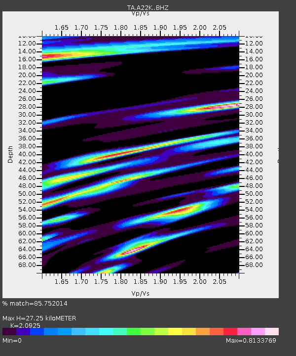
| Estimated Moho Depth: |
27.25 km |
| Estimated Crust Vp/Vs: |
2.09 |
| Assumed Crust Vp: |
5.782 km/s |
| Estimated Crust Vs: |
2.763 km/s |
| Estimated Crust Poisson's Ratio: |
0.35 |
|
| Radial Match: |
85.752014 % |
| Radial Bump: |
360 |
| Transverse Match: |
73.82586 % |
| Transverse Bump: |
400 |
| SOD ConfigId: |
18252611 |
| Insert Time: |
2019-05-06 21:56:57.193 +0000 |
| GWidth: |
2.5 |
| Max Bumps: |
400 |
| Tol: |
0.001 |
|

Signal To Noise
| Channel | StoN | STA | LTA |
| TA:A22K: :BHZ:20190422T09:22:15.84998Z | 6.733618 | 9.735818E-7 | 1.4458524E-7 |
| TA:A22K: :BHN:20190422T09:22:15.84998Z | 0.77233523 | 1.532124E-7 | 1.9837552E-7 |
| TA:A22K: :BHE:20190422T09:22:15.84998Z | 1.6006178 | 3.1341432E-7 | 1.9580834E-7 |
| Arrivals |
| Ps | 5.3 SECOND |
| PpPs | 14 SECOND |
| PsPs/PpSs | 20 SECOND |


