You are here: Home > Network List > TA - USArray Transportable Network (new EarthScope stations) Stations List
> Station C16K Lisburne Hills, AK, USA > Earthquake Result Viewer
C16K Lisburne Hills, AK, USA - Earthquake Result Viewer
| Earthquake location: |
Luzon, Philippines |
| Earthquake latitude/longitude: |
14.9/120.5 |
| Earthquake time(UTC): |
2019/04/22 (112) 09:11:11 GMT |
| Earthquake Depth: |
20 km |
| Earthquake Magnitude: |
6.1 Mww |
| Earthquake Catalog/Contributor: |
NEIC PDE/us |
|
| Network: |
TA USArray Transportable Network (new EarthScope stations) |
| Station: |
C16K Lisburne Hills, AK, USA |
| Lat/Lon: |
68.27 N/165.34 W |
| Elevation: |
102 m |
|
| Distance: |
70.4 deg |
| Az: |
22.349 deg |
| Baz: |
260.86 deg |
| Ray Param: |
0.05500065 |
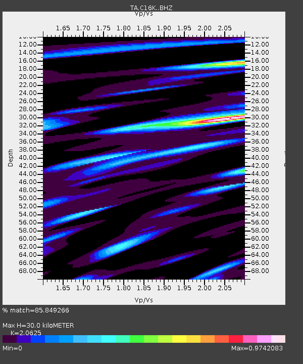
| Estimated Moho Depth: |
30.0 km |
| Estimated Crust Vp/Vs: |
2.06 |
| Assumed Crust Vp: |
5.906 km/s |
| Estimated Crust Vs: |
2.864 km/s |
| Estimated Crust Poisson's Ratio: |
0.35 |
|
| Radial Match: |
85.849266 % |
| Radial Bump: |
335 |
| Transverse Match: |
71.85032 % |
| Transverse Bump: |
400 |
| SOD ConfigId: |
18252611 |
| Insert Time: |
2019-05-06 21:56:59.921 +0000 |
| GWidth: |
2.5 |
| Max Bumps: |
400 |
| Tol: |
0.001 |
|
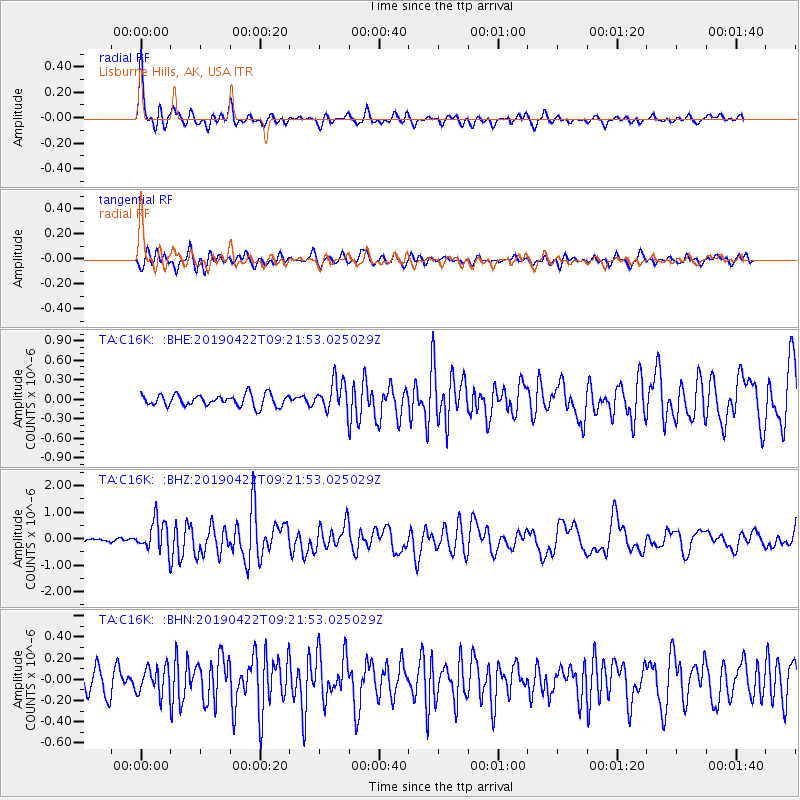
Signal To Noise
| Channel | StoN | STA | LTA |
| TA:C16K: :BHZ:20190422T09:21:53.025029Z | 6.579561 | 5.755777E-7 | 8.747965E-8 |
| TA:C16K: :BHN:20190422T09:21:53.025029Z | 1.1976453 | 1.2823301E-7 | 1.0707094E-7 |
| TA:C16K: :BHE:20190422T09:21:53.025029Z | 2.5443017 | 2.2886236E-7 | 8.995095E-8 |
| Arrivals |
| Ps | 5.5 SECOND |
| PpPs | 15 SECOND |
| PsPs/PpSs | 21 SECOND |


