You are here: Home > Network List > TA - USArray Transportable Network (new EarthScope stations) Stations List
> Station C18K Utukok River, AK, USA > Earthquake Result Viewer
C18K Utukok River, AK, USA - Earthquake Result Viewer
| Earthquake location: |
Luzon, Philippines |
| Earthquake latitude/longitude: |
14.9/120.5 |
| Earthquake time(UTC): |
2019/04/22 (112) 09:11:11 GMT |
| Earthquake Depth: |
20 km |
| Earthquake Magnitude: |
6.1 Mww |
| Earthquake Catalog/Contributor: |
NEIC PDE/us |
|
| Network: |
TA USArray Transportable Network (new EarthScope stations) |
| Station: |
C18K Utukok River, AK, USA |
| Lat/Lon: |
68.65 N/161.19 W |
| Elevation: |
845 m |
|
| Distance: |
71.9 deg |
| Az: |
22.16 deg |
| Baz: |
264.655 deg |
| Ray Param: |
0.05396752 |
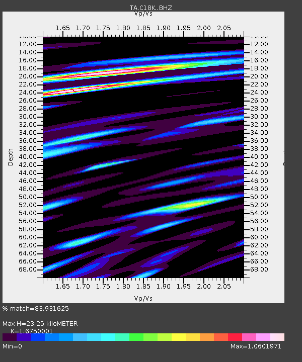
| Estimated Moho Depth: |
23.25 km |
| Estimated Crust Vp/Vs: |
1.68 |
| Assumed Crust Vp: |
5.906 km/s |
| Estimated Crust Vs: |
3.526 km/s |
| Estimated Crust Poisson's Ratio: |
0.22 |
|
| Radial Match: |
83.931625 % |
| Radial Bump: |
400 |
| Transverse Match: |
82.87079 % |
| Transverse Bump: |
400 |
| SOD ConfigId: |
18252611 |
| Insert Time: |
2019-05-06 21:57:00.915 +0000 |
| GWidth: |
2.5 |
| Max Bumps: |
400 |
| Tol: |
0.001 |
|

Signal To Noise
| Channel | StoN | STA | LTA |
| TA:C18K: :BHZ:20190422T09:22:02.47498Z | 6.1452093 | 4.446111E-7 | 7.235085E-8 |
| TA:C18K: :BHN:20190422T09:22:02.47498Z | 2.7253497 | 1.1068957E-7 | 4.0614815E-8 |
| TA:C18K: :BHE:20190422T09:22:02.47498Z | 2.808234 | 1.9334053E-7 | 6.8847726E-8 |
| Arrivals |
| Ps | 2.7 SECOND |
| PpPs | 10 SECOND |
| PsPs/PpSs | 13 SECOND |


