You are here: Home > Network List > TA - USArray Transportable Network (new EarthScope stations) Stations List
> Station E19K Redstone River, AK, USA > Earthquake Result Viewer
E19K Redstone River, AK, USA - Earthquake Result Viewer
| Earthquake location: |
Luzon, Philippines |
| Earthquake latitude/longitude: |
14.9/120.5 |
| Earthquake time(UTC): |
2019/04/22 (112) 09:11:11 GMT |
| Earthquake Depth: |
20 km |
| Earthquake Magnitude: |
6.1 Mww |
| Earthquake Catalog/Contributor: |
NEIC PDE/us |
|
| Network: |
TA USArray Transportable Network (new EarthScope stations) |
| Station: |
E19K Redstone River, AK, USA |
| Lat/Lon: |
67.46 N/157.23 W |
| Elevation: |
441 m |
|
| Distance: |
73.4 deg |
| Az: |
23.501 deg |
| Baz: |
268.728 deg |
| Ray Param: |
0.05303252 |
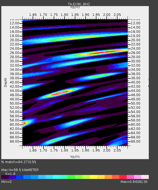
| Estimated Moho Depth: |
59.5 km |
| Estimated Crust Vp/Vs: |
1.60 |
| Assumed Crust Vp: |
6.577 km/s |
| Estimated Crust Vs: |
4.11 km/s |
| Estimated Crust Poisson's Ratio: |
0.18 |
|
| Radial Match: |
84.273155 % |
| Radial Bump: |
319 |
| Transverse Match: |
85.65137 % |
| Transverse Bump: |
379 |
| SOD ConfigId: |
18252611 |
| Insert Time: |
2019-05-06 21:57:10.462 +0000 |
| GWidth: |
2.5 |
| Max Bumps: |
400 |
| Tol: |
0.001 |
|

Signal To Noise
| Channel | StoN | STA | LTA |
| TA:E19K: :BHZ:20190422T09:22:10.875005Z | 8.038634 | 5.1666467E-7 | 6.427269E-8 |
| TA:E19K: :BHN:20190422T09:22:10.875005Z | 2.9972684 | 1.646726E-7 | 5.4940887E-8 |
| TA:E19K: :BHE:20190422T09:22:10.875005Z | 3.905179 | 2.170462E-7 | 5.557907E-8 |
| Arrivals |
| Ps | 5.6 SECOND |
| PpPs | 23 SECOND |
| PsPs/PpSs | 28 SECOND |


