You are here: Home > Network List > TA - USArray Transportable Network (new EarthScope stations) Stations List
> Station E23K Chandalar, AK, USA > Earthquake Result Viewer
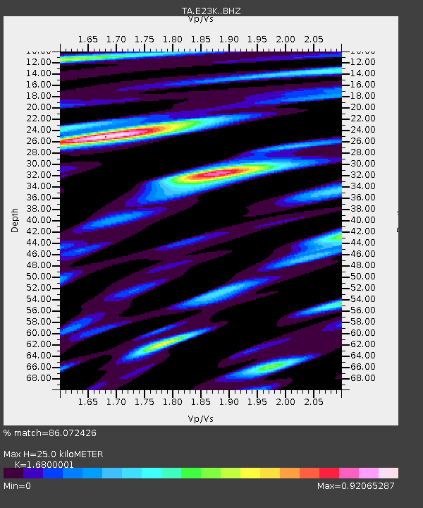
E23K Chandalar, AK, USA - Earthquake Result Viewer
| Earthquake location: |
Luzon, Philippines |
| Earthquake latitude/longitude: |
14.9/120.5 |
| Earthquake time(UTC): |
2019/04/22 (112) 09:11:11 GMT |
| Earthquake Depth: |
20 km |
| Earthquake Magnitude: |
6.1 Mww |
| Earthquake Catalog/Contributor: |
NEIC PDE/us |
|
| Network: |
TA USArray Transportable Network (new EarthScope stations) |
| Station: |
E23K Chandalar, AK, USA |
| Lat/Lon: |
68.06 N/149.62 W |
| Elevation: |
1084 m |
|
| Distance: |
76.2 deg |
| Az: |
22.764 deg |
| Baz: |
275.578 deg |
| Ray Param: |
0.05110933 |
| Estimated Moho Depth: |
25.0 km |
| Estimated Crust Vp/Vs: |
1.68 |
| Assumed Crust Vp: |
6.316 km/s |
| Estimated Crust Vs: |
3.76 km/s |
| Estimated Crust Poisson's Ratio: |
0.23 |
|
| Radial Match: |
86.072426 % |
| Radial Bump: |
391 |
| Transverse Match: |
72.58785 % |
| Transverse Bump: |
400 |
| SOD ConfigId: |
18252611 |
| Insert Time: |
2019-05-06 21:57:12.067 +0000 |
| GWidth: |
2.5 |
| Max Bumps: |
400 |
| Tol: |
0.001 |
|

Signal To Noise
| Channel | StoN | STA | LTA |
| TA:E23K: :BHZ:20190422T09:22:27.47498Z | 4.1369534 | 5.447058E-7 | 1.3166834E-7 |
| TA:E23K: :BHN:20190422T09:22:27.47498Z | 0.7694684 | 8.307602E-8 | 1.0796547E-7 |
| TA:E23K: :BHE:20190422T09:22:27.47498Z | 1.9989517 | 1.5229132E-7 | 7.61856E-8 |
| Arrivals |
| Ps | 2.8 SECOND |
| PpPs | 10 SECOND |
| PsPs/PpSs | 13 SECOND |


