You are here: Home > Network List > TA - USArray Transportable Network (new EarthScope stations) Stations List
> Station D14A Greenough, MT, USA > Earthquake Result Viewer
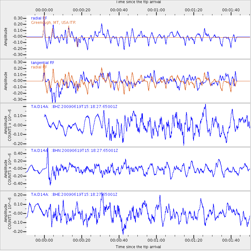
D14A Greenough, MT, USA - Earthquake Result Viewer
*The percent match for this event was below the threshold and hence no stack was calculated.
| Earthquake location: |
Mariana Islands |
| Earthquake latitude/longitude: |
14.1/145.2 |
| Earthquake time(UTC): |
2009/06/19 (170) 15:06:24 GMT |
| Earthquake Depth: |
114 km |
| Earthquake Magnitude: |
5.5 MB, 5.5 MW |
| Earthquake Catalog/Contributor: |
WHDF/NEIC |
|
| Network: |
TA USArray Transportable Network (new EarthScope stations) |
| Station: |
D14A Greenough, MT, USA |
| Lat/Lon: |
47.08 N/113.51 W |
| Elevation: |
1444 m |
|
| Distance: |
87.3 deg |
| Az: |
42.134 deg |
| Baz: |
287.719 deg |
| Ray Param: |
$rayparam |
*The percent match for this event was below the threshold and hence was not used in the summary stack. |
|
| Radial Match: |
63.912624 % |
| Radial Bump: |
400 |
| Transverse Match: |
64.97778 % |
| Transverse Bump: |
400 |
| SOD ConfigId: |
2648 |
| Insert Time: |
2010-03-06 21:36:20.939 +0000 |
| GWidth: |
2.5 |
| Max Bumps: |
400 |
| Tol: |
0.001 |
|
Signal To Noise
| Channel | StoN | STA | LTA |
| TA:D14A: :BHN:20090619T15:18:27.65001Z | 3.204197 | 2.1877328E-7 | 6.82771E-8 |
| TA:D14A: :BHE:20090619T15:18:27.65001Z | 0.751507 | 5.4570297E-8 | 7.261449E-8 |
| TA:D14A: :BHZ:20090619T15:18:27.65001Z | 1.3977667 | 7.3476315E-8 | 5.256694E-8 |
| Arrivals |
| Ps | |
| PpPs | |
| PsPs/PpSs | |


