You are here: Home > Network List > TA - USArray Transportable Network (new EarthScope stations) Stations List
> Station F21K Alatna River, AK, USA > Earthquake Result Viewer
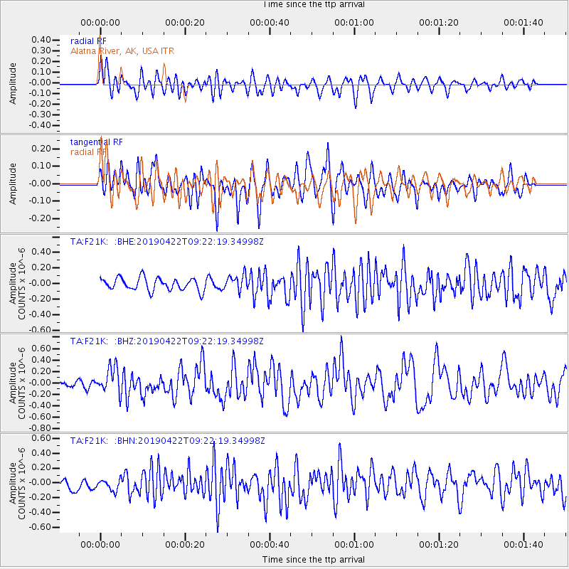
F21K Alatna River, AK, USA - Earthquake Result Viewer
*The percent match for this event was below the threshold and hence no stack was calculated.
| Earthquake location: |
Luzon, Philippines |
| Earthquake latitude/longitude: |
14.9/120.5 |
| Earthquake time(UTC): |
2019/04/22 (112) 09:11:11 GMT |
| Earthquake Depth: |
20 km |
| Earthquake Magnitude: |
6.1 Mww |
| Earthquake Catalog/Contributor: |
NEIC PDE/us |
|
| Network: |
TA USArray Transportable Network (new EarthScope stations) |
| Station: |
F21K Alatna River, AK, USA |
| Lat/Lon: |
67.22 N/153.48 W |
| Elevation: |
597 m |
|
| Distance: |
74.8 deg |
| Az: |
23.733 deg |
| Baz: |
272.247 deg |
| Ray Param: |
$rayparam |
*The percent match for this event was below the threshold and hence was not used in the summary stack. |
|
| Radial Match: |
56.29721 % |
| Radial Bump: |
400 |
| Transverse Match: |
52.70516 % |
| Transverse Bump: |
400 |
| SOD ConfigId: |
18252611 |
| Insert Time: |
2019-05-06 21:57:19.202 +0000 |
| GWidth: |
2.5 |
| Max Bumps: |
400 |
| Tol: |
0.001 |
|
Signal To Noise
| Channel | StoN | STA | LTA |
| TA:F21K: :BHZ:20190422T09:22:19.34998Z | 2.5962164 | 2.3490612E-7 | 9.048018E-8 |
| TA:F21K: :BHN:20190422T09:22:19.34998Z | 1.2351878 | 7.938974E-8 | 6.4273415E-8 |
| TA:F21K: :BHE:20190422T09:22:19.34998Z | 1.2461458 | 9.952968E-8 | 7.9870006E-8 |
| Arrivals |
| Ps | |
| PpPs | |
| PsPs/PpSs | |


