You are here: Home > Network List > BK - Berkeley Digital Seismograph Network Stations List
> Station HUMO Hull Mountain, OR > Earthquake Result Viewer
HUMO Hull Mountain, OR - Earthquake Result Viewer
*The percent match for this event was below the threshold and hence no stack was calculated.
| Earthquake location: |
East Of Kuril Islands |
| Earthquake latitude/longitude: |
44.0/148.2 |
| Earthquake time(UTC): |
2016/10/23 (297) 20:25:26 GMT |
| Earthquake Depth: |
30 km |
| Earthquake Magnitude: |
5.8 MB |
| Earthquake Catalog/Contributor: |
NEIC PDE/NEIC COMCAT |
|
| Network: |
BK Berkeley Digital Seismograph Network |
| Station: |
HUMO Hull Mountain, OR |
| Lat/Lon: |
42.61 N/122.96 W |
| Elevation: |
555 m |
|
| Distance: |
61.5 deg |
| Az: |
57.132 deg |
| Baz: |
304.787 deg |
| Ray Param: |
$rayparam |
*The percent match for this event was below the threshold and hence was not used in the summary stack. |
|
| Radial Match: |
63.875187 % |
| Radial Bump: |
400 |
| Transverse Match: |
68.85174 % |
| Transverse Bump: |
400 |
| SOD ConfigId: |
1815711 |
| Insert Time: |
2016-11-06 20:26:08.934 +0000 |
| GWidth: |
2.5 |
| Max Bumps: |
400 |
| Tol: |
0.001 |
|
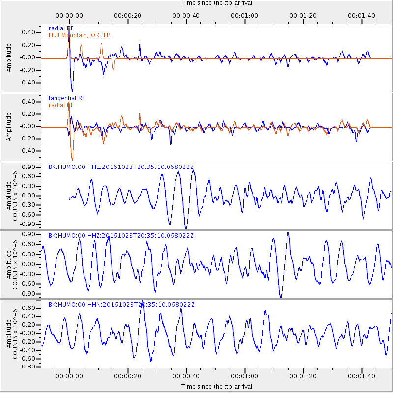
Signal To Noise
| Channel | StoN | STA | LTA |
| BK:HUMO:00:HHZ:20161023T20:35:10.068022Z | 1.2973343 | 4.2562348E-7 | 3.280754E-7 |
| BK:HUMO:00:HHN:20161023T20:35:10.068022Z | 1.4863459 | 2.7336256E-7 | 1.8391584E-7 |
| BK:HUMO:00:HHE:20161023T20:35:10.068022Z | 2.364719 | 5.2123653E-7 | 2.204222E-7 |
| Arrivals |
| Ps | |
| PpPs | |
| PsPs/PpSs | |


