You are here: Home > Network List > TA - USArray Transportable Network (new EarthScope stations) Stations List
> Station D14A Greenough, MT, USA > Earthquake Result Viewer
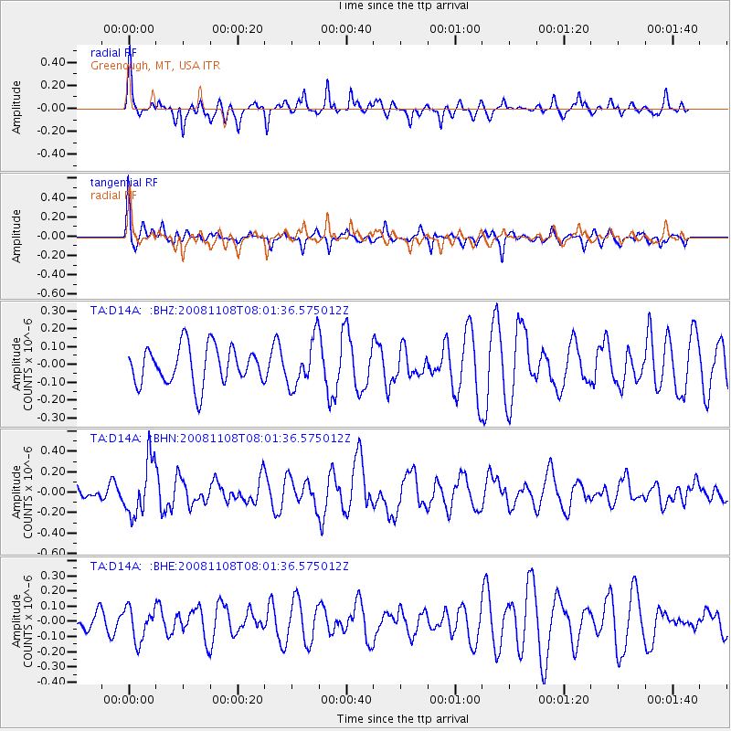
D14A Greenough, MT, USA - Earthquake Result Viewer
*The percent match for this event was below the threshold and hence no stack was calculated.
| Earthquake location: |
Tonga Islands |
| Earthquake latitude/longitude: |
-15.2/-174.2 |
| Earthquake time(UTC): |
2008/11/08 (313) 07:49:59 GMT |
| Earthquake Depth: |
121 km |
| Earthquake Magnitude: |
6.0 MW, 5.4 MB, 6.0 MW |
| Earthquake Catalog/Contributor: |
WHDF/NEIC |
|
| Network: |
TA USArray Transportable Network (new EarthScope stations) |
| Station: |
D14A Greenough, MT, USA |
| Lat/Lon: |
47.08 N/113.51 W |
| Elevation: |
1444 m |
|
| Distance: |
82.4 deg |
| Az: |
36.97 deg |
| Baz: |
238.159 deg |
| Ray Param: |
$rayparam |
*The percent match for this event was below the threshold and hence was not used in the summary stack. |
|
| Radial Match: |
67.966705 % |
| Radial Bump: |
396 |
| Transverse Match: |
50.78185 % |
| Transverse Bump: |
400 |
| SOD ConfigId: |
2658 |
| Insert Time: |
2010-03-06 21:36:32.062 +0000 |
| GWidth: |
2.5 |
| Max Bumps: |
400 |
| Tol: |
0.001 |
|
Signal To Noise
| Channel | StoN | STA | LTA |
| TA:D14A: :BHN:20081108T08:01:36.575012Z | 2.5696647 | 2.7163256E-7 | 1.05707386E-7 |
| TA:D14A: :BHE:20081108T08:01:36.575012Z | 1.0667096 | 1.08656806E-7 | 1.0186165E-7 |
| TA:D14A: :BHZ:20081108T08:01:36.575012Z | 1.2706635 | 1.3408749E-7 | 1.0552557E-7 |
| Arrivals |
| Ps | |
| PpPs | |
| PsPs/PpSs | |


