You are here: Home > Network List > TA - USArray Transportable Network (new EarthScope stations) Stations List
> Station D14A Greenough, MT, USA > Earthquake Result Viewer
D14A Greenough, MT, USA - Earthquake Result Viewer
*The percent match for this event was below the threshold and hence no stack was calculated.
| Earthquake location: |
Tonga Islands Region |
| Earthquake latitude/longitude: |
-22.5/-174.7 |
| Earthquake time(UTC): |
2009/04/04 (094) 11:07:12 GMT |
| Earthquake Depth: |
35 km |
| Earthquake Magnitude: |
5.5 MB, 5.4 MS, 5.5 MW, 5.5 MW |
| Earthquake Catalog/Contributor: |
WHDF/NEIC |
|
| Network: |
TA USArray Transportable Network (new EarthScope stations) |
| Station: |
D14A Greenough, MT, USA |
| Lat/Lon: |
47.08 N/113.51 W |
| Elevation: |
1444 m |
|
| Distance: |
88.5 deg |
| Az: |
36.784 deg |
| Baz: |
234.117 deg |
| Ray Param: |
$rayparam |
*The percent match for this event was below the threshold and hence was not used in the summary stack. |
|
| Radial Match: |
47.376785 % |
| Radial Bump: |
400 |
| Transverse Match: |
48.60032 % |
| Transverse Bump: |
400 |
| SOD ConfigId: |
2658 |
| Insert Time: |
2010-03-06 21:36:47.140 +0000 |
| GWidth: |
2.5 |
| Max Bumps: |
400 |
| Tol: |
0.001 |
|
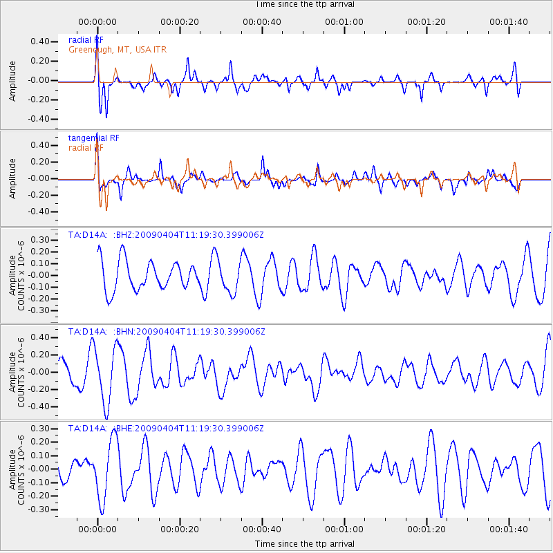
Signal To Noise
| Channel | StoN | STA | LTA |
| TA:D14A: :BHN:20090404T11:19:30.399006Z | 1.9529587 | 3.18974E-7 | 1.633286E-7 |
| TA:D14A: :BHE:20090404T11:19:30.399006Z | 2.622097 | 2.2618082E-7 | 8.625951E-8 |
| TA:D14A: :BHZ:20090404T11:19:30.399006Z | 1.0533785 | 1.2859608E-7 | 1.2207965E-7 |
| Arrivals |
| Ps | |
| PpPs | |
| PsPs/PpSs | |


