You are here: Home > Network List > GO - National Seismic Network of Georgia Stations List
> Station ONI Oni > Earthquake Result Viewer
ONI Oni - Earthquake Result Viewer
| Earthquake location: |
East Of Kuril Islands |
| Earthquake latitude/longitude: |
44.0/148.2 |
| Earthquake time(UTC): |
2016/10/23 (297) 20:25:26 GMT |
| Earthquake Depth: |
30 km |
| Earthquake Magnitude: |
5.8 MB |
| Earthquake Catalog/Contributor: |
NEIC PDE/NEIC COMCAT |
|
| Network: |
GO National Seismic Network of Georgia |
| Station: |
ONI Oni |
| Lat/Lon: |
42.59 N/43.45 E |
| Elevation: |
810 m |
|
| Distance: |
70.7 deg |
| Az: |
310.799 deg |
| Baz: |
47.732 deg |
| Ray Param: |
0.05479681 |
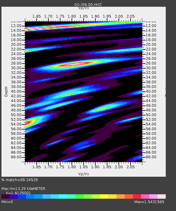
| Estimated Moho Depth: |
13.25 km |
| Estimated Crust Vp/Vs: |
1.61 |
| Assumed Crust Vp: |
6.247 km/s |
| Estimated Crust Vs: |
3.874 km/s |
| Estimated Crust Poisson's Ratio: |
0.19 |
|
| Radial Match: |
89.34529 % |
| Radial Bump: |
400 |
| Transverse Match: |
82.5702 % |
| Transverse Bump: |
400 |
| SOD ConfigId: |
1815711 |
| Insert Time: |
2016-11-06 20:26:45.445 +0000 |
| GWidth: |
2.5 |
| Max Bumps: |
400 |
| Tol: |
0.001 |
|
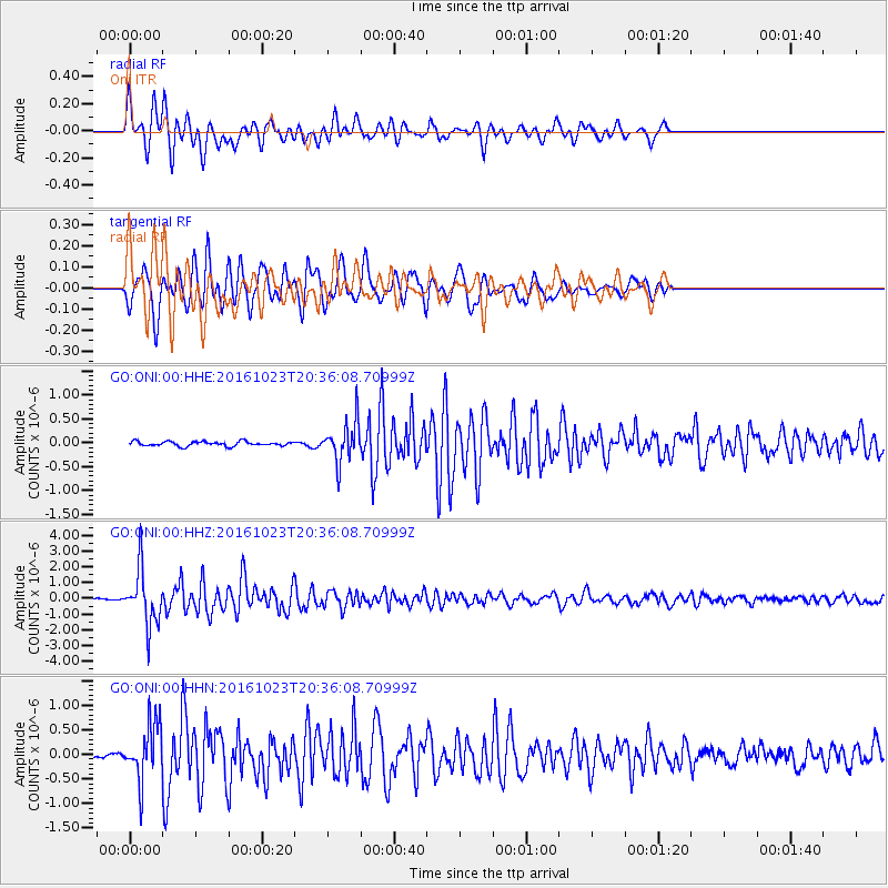
Signal To Noise
| Channel | StoN | STA | LTA |
| GO:ONI:00:HHZ:20161023T20:36:08.70999Z | 28.132566 | 1.7529748E-6 | 6.231123E-8 |
| GO:ONI:00:HHN:20161023T20:36:08.70999Z | 11.150998 | 5.7849934E-7 | 5.1878708E-8 |
| GO:ONI:00:HHE:20161023T20:36:08.70999Z | 8.744618 | 4.123724E-7 | 4.715728E-8 |
| Arrivals |
| Ps | 1.3 SECOND |
| PpPs | 5.3 SECOND |
| PsPs/PpSs | 6.7 SECOND |


