You are here: Home > Network List > TA - USArray Transportable Network (new EarthScope stations) Stations List
> Station D14A Greenough, MT, USA > Earthquake Result Viewer
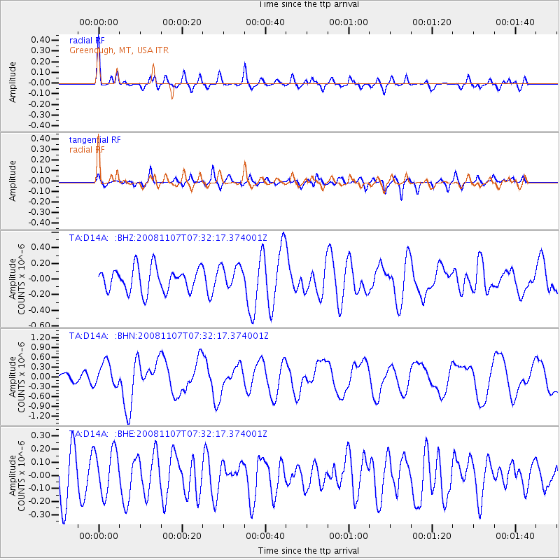
D14A Greenough, MT, USA - Earthquake Result Viewer
*The percent match for this event was below the threshold and hence no stack was calculated.
| Earthquake location: |
Vanuatu Islands |
| Earthquake latitude/longitude: |
-14.8/168.0 |
| Earthquake time(UTC): |
2008/11/07 (312) 07:19:35 GMT |
| Earthquake Depth: |
13 km |
| Earthquake Magnitude: |
6.0 MB, 6.3 MS, 6.4 MW, 6.4 MW |
| Earthquake Catalog/Contributor: |
WHDF/NEIC |
|
| Network: |
TA USArray Transportable Network (new EarthScope stations) |
| Station: |
D14A Greenough, MT, USA |
| Lat/Lon: |
47.08 N/113.51 W |
| Elevation: |
1444 m |
|
| Distance: |
93.1 deg |
| Az: |
42.11 deg |
| Baz: |
251.61 deg |
| Ray Param: |
$rayparam |
*The percent match for this event was below the threshold and hence was not used in the summary stack. |
|
| Radial Match: |
66.3331 % |
| Radial Bump: |
344 |
| Transverse Match: |
53.611843 % |
| Transverse Bump: |
400 |
| SOD ConfigId: |
2658 |
| Insert Time: |
2010-03-06 21:37:03.454 +0000 |
| GWidth: |
2.5 |
| Max Bumps: |
400 |
| Tol: |
0.001 |
|
Signal To Noise
| Channel | StoN | STA | LTA |
| TA:D14A: :BHN:20081107T07:32:17.374001Z | 2.2739258 | 3.6485207E-7 | 1.604503E-7 |
| TA:D14A: :BHE:20081107T07:32:17.374001Z | 0.78911453 | 1.754713E-7 | 2.223648E-7 |
| TA:D14A: :BHZ:20081107T07:32:17.374001Z | 0.9619203 | 1.4474914E-7 | 1.5047934E-7 |
| Arrivals |
| Ps | |
| PpPs | |
| PsPs/PpSs | |


