You are here: Home > Network List > TS - TERRAscope (Southern California Seismic Network) Stations List
> Station DGR Domenigoni Valley Reservior, California, USA > Earthquake Result Viewer
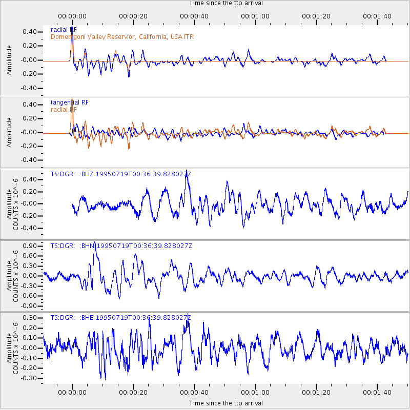
DGR Domenigoni Valley Reservior, California, USA - Earthquake Result Viewer
*The percent match for this event was below the threshold and hence no stack was calculated.
| Earthquake location: |
Southeast Of Loyalty Islands |
| Earthquake latitude/longitude: |
-22.7/169.7 |
| Earthquake time(UTC): |
1995/07/19 (200) 00:24:17 GMT |
| Earthquake Depth: |
32 km |
| Earthquake Magnitude: |
5.8 MB, 5.6 MS, 5.4 UNKNOWN, 6.0 MW |
| Earthquake Catalog/Contributor: |
WHDF/NEIC |
|
| Network: |
TS TERRAscope (Southern California Seismic Network) |
| Station: |
DGR Domenigoni Valley Reservior, California, USA |
| Lat/Lon: |
33.65 N/117.01 W |
| Elevation: |
700 m |
|
| Distance: |
89.4 deg |
| Az: |
53.018 deg |
| Baz: |
242.183 deg |
| Ray Param: |
$rayparam |
*The percent match for this event was below the threshold and hence was not used in the summary stack. |
|
| Radial Match: |
61.579384 % |
| Radial Bump: |
400 |
| Transverse Match: |
52.1446 % |
| Transverse Bump: |
400 |
| SOD ConfigId: |
4480 |
| Insert Time: |
2010-02-26 14:10:56.014 +0000 |
| GWidth: |
2.5 |
| Max Bumps: |
400 |
| Tol: |
0.001 |
|
Signal To Noise
| Channel | StoN | STA | LTA |
| TS:DGR: :BHN:19950719T00:36:39.828027Z | 2.4014475 | 1.5625834E-7 | 6.50684E-8 |
| TS:DGR: :BHE:19950719T00:36:39.828027Z | 0.9843277 | 7.220502E-8 | 7.3354656E-8 |
| TS:DGR: :BHZ:19950719T00:36:39.828027Z | 1.9856167 | 1.7017264E-7 | 8.5702666E-8 |
| Arrivals |
| Ps | |
| PpPs | |
| PsPs/PpSs | |


