You are here: Home > Network List > AK - Alaska Regional Network Stations List
> Station KNK Knik Glacier, AK, USA > Earthquake Result Viewer
KNK Knik Glacier, AK, USA - Earthquake Result Viewer
| Earthquake location: |
Samar, Philippines |
| Earthquake latitude/longitude: |
11.8/125.2 |
| Earthquake time(UTC): |
2019/04/23 (113) 05:37:52 GMT |
| Earthquake Depth: |
54 km |
| Earthquake Magnitude: |
6.4 Mww |
| Earthquake Catalog/Contributor: |
NEIC PDE/us |
|
| Network: |
AK Alaska Regional Network |
| Station: |
KNK Knik Glacier, AK, USA |
| Lat/Lon: |
61.41 N/148.46 W |
| Elevation: |
598 m |
|
| Distance: |
78.0 deg |
| Az: |
29.394 deg |
| Baz: |
272.551 deg |
| Ray Param: |
0.049871527 |
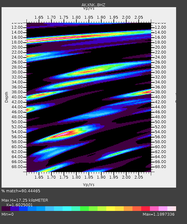
| Estimated Moho Depth: |
17.25 km |
| Estimated Crust Vp/Vs: |
1.60 |
| Assumed Crust Vp: |
6.566 km/s |
| Estimated Crust Vs: |
4.097 km/s |
| Estimated Crust Poisson's Ratio: |
0.18 |
|
| Radial Match: |
90.44465 % |
| Radial Bump: |
400 |
| Transverse Match: |
86.54131 % |
| Transverse Bump: |
400 |
| SOD ConfigId: |
18252611 |
| Insert Time: |
2019-05-07 05:38:29.338 +0000 |
| GWidth: |
2.5 |
| Max Bumps: |
400 |
| Tol: |
0.001 |
|

Signal To Noise
| Channel | StoN | STA | LTA |
| AK:KNK: :BHZ:20190423T05:49:14.327999Z | 13.764506 | 2.8579943E-6 | 2.0763507E-7 |
| AK:KNK: :BHN:20190423T05:49:14.327999Z | 7.161216 | 7.3905244E-7 | 1.0320209E-7 |
| AK:KNK: :BHE:20190423T05:49:14.327999Z | 12.814465 | 1.5274798E-6 | 1.19199655E-7 |
| Arrivals |
| Ps | 1.6 SECOND |
| PpPs | 6.6 SECOND |
| PsPs/PpSs | 8.2 SECOND |


