You are here: Home > Network List > TA - USArray Transportable Network (new EarthScope stations) Stations List
> Station M15A Larsen Ranch, Promontory, UT, USA > Earthquake Result Viewer
M15A Larsen Ranch, Promontory, UT, USA - Earthquake Result Viewer
| Earthquake location: |
Southern Bolivia |
| Earthquake latitude/longitude: |
-20.1/-65.0 |
| Earthquake time(UTC): |
2008/10/12 (286) 20:55:41 GMT |
| Earthquake Depth: |
353 km |
| Earthquake Magnitude: |
6.0 MB, 6.2 MW, 6.2 MW |
| Earthquake Catalog/Contributor: |
WHDF/NEIC |
|
| Network: |
TA USArray Transportable Network (new EarthScope stations) |
| Station: |
M15A Larsen Ranch, Promontory, UT, USA |
| Lat/Lon: |
41.46 N/112.45 W |
| Elevation: |
1348 m |
|
| Distance: |
75.4 deg |
| Az: |
325.085 deg |
| Baz: |
134.307 deg |
| Ray Param: |
0.05067102 |
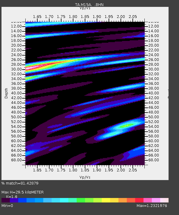
| Estimated Moho Depth: |
29.5 km |
| Estimated Crust Vp/Vs: |
1.60 |
| Assumed Crust Vp: |
6.276 km/s |
| Estimated Crust Vs: |
3.922 km/s |
| Estimated Crust Poisson's Ratio: |
0.18 |
|
| Radial Match: |
81.42879 % |
| Radial Bump: |
400 |
| Transverse Match: |
64.63321 % |
| Transverse Bump: |
400 |
| SOD ConfigId: |
2556 |
| Insert Time: |
2010-03-06 21:37:48.293 +0000 |
| GWidth: |
2.5 |
| Max Bumps: |
400 |
| Tol: |
0.001 |
|
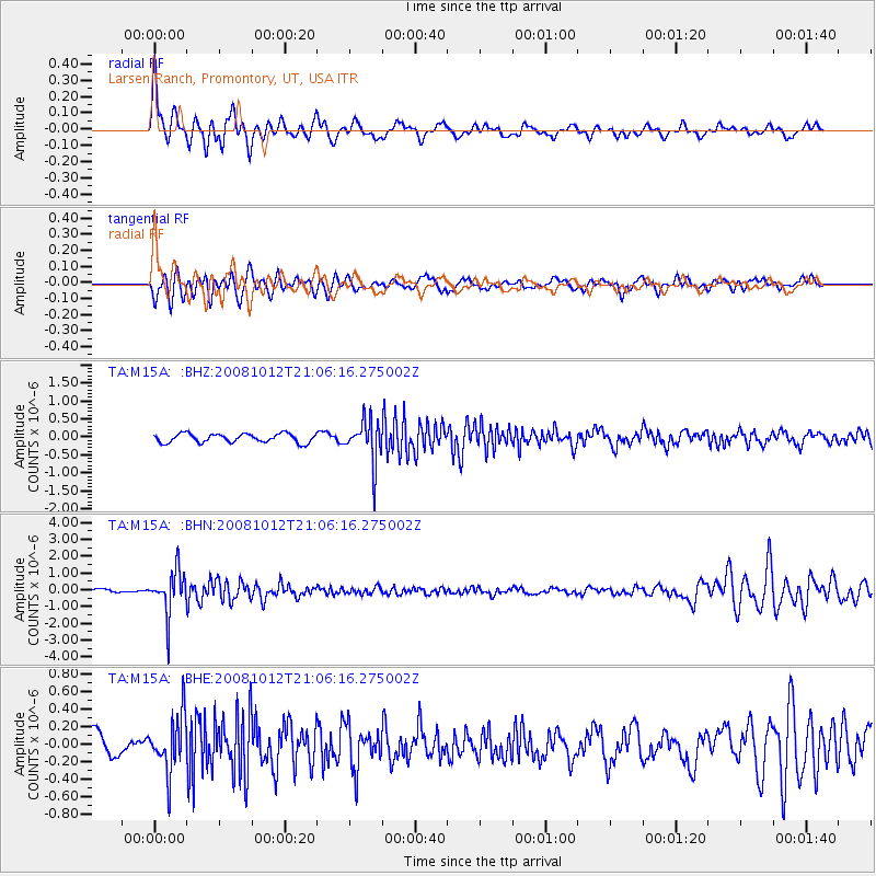
Signal To Noise
| Channel | StoN | STA | LTA |
| TA:M15A: :BHN:20081012T21:06:16.275002Z | 11.739128 | 1.2904875E-6 | 1.0993045E-7 |
| TA:M15A: :BHE:20081012T21:06:16.275002Z | 2.861085 | 3.2028848E-7 | 1.1194651E-7 |
| TA:M15A: :BHZ:20081012T21:06:16.275002Z | 4.741722 | 5.838652E-7 | 1.2313357E-7 |
| Arrivals |
| Ps | 2.9 SECOND |
| PpPs | 12 SECOND |
| PsPs/PpSs | 15 SECOND |


