You are here: Home > Network List > IU - Global Seismograph Network (GSN - IRIS/USGS) Stations List
> Station FURI Mt. Furi, Ethiopia > Earthquake Result Viewer
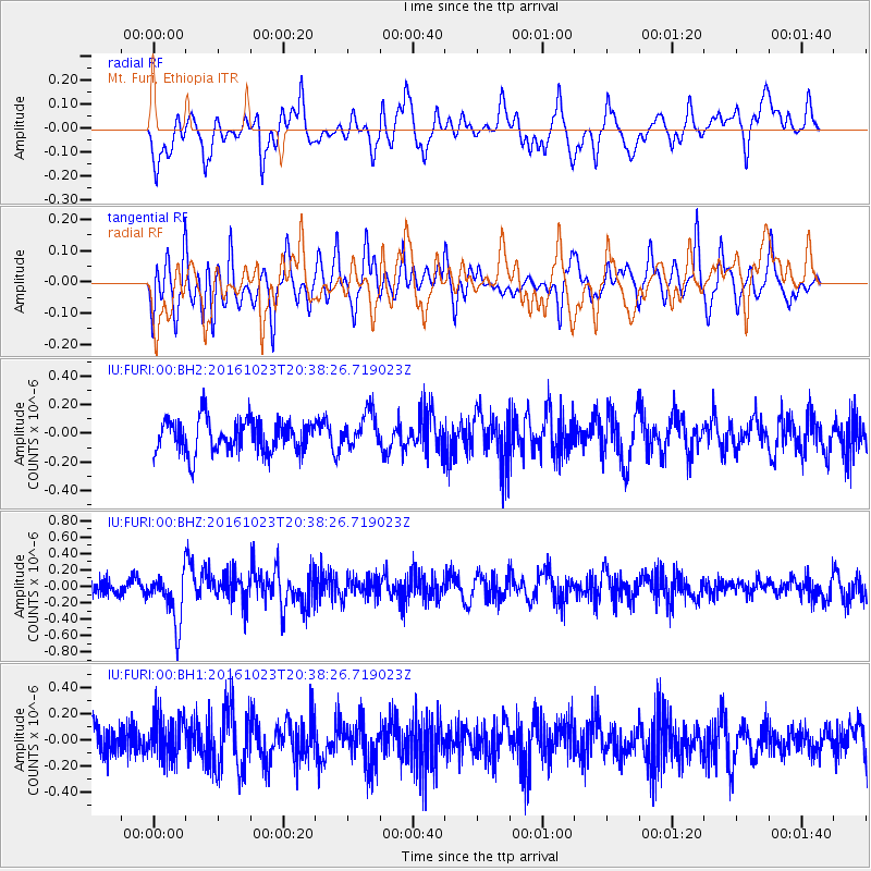
FURI Mt. Furi, Ethiopia - Earthquake Result Viewer
*The percent match for this event was below the threshold and hence no stack was calculated.
| Earthquake location: |
East Of Kuril Islands |
| Earthquake latitude/longitude: |
44.0/148.2 |
| Earthquake time(UTC): |
2016/10/23 (297) 20:25:26 GMT |
| Earthquake Depth: |
30 km |
| Earthquake Magnitude: |
5.8 MB |
| Earthquake Catalog/Contributor: |
NEIC PDE/NEIC COMCAT |
|
| Network: |
IU Global Seismograph Network (GSN - IRIS/USGS) |
| Station: |
FURI Mt. Furi, Ethiopia |
| Lat/Lon: |
8.90 N/38.68 E |
| Elevation: |
2570 m |
|
| Distance: |
97.6 deg |
| Az: |
289.994 deg |
| Baz: |
43.356 deg |
| Ray Param: |
$rayparam |
*The percent match for this event was below the threshold and hence was not used in the summary stack. |
|
| Radial Match: |
63.467247 % |
| Radial Bump: |
400 |
| Transverse Match: |
60.268806 % |
| Transverse Bump: |
387 |
| SOD ConfigId: |
1815711 |
| Insert Time: |
2016-11-06 20:27:51.029 +0000 |
| GWidth: |
2.5 |
| Max Bumps: |
400 |
| Tol: |
0.001 |
|
Signal To Noise
| Channel | StoN | STA | LTA |
| IU:FURI:00:BHZ:20161023T20:38:26.719023Z | 2.5094173 | 3.0324287E-7 | 1.2084196E-7 |
| IU:FURI:00:BH1:20161023T20:38:26.719023Z | 1.6595962 | 1.7351704E-7 | 1.0455377E-7 |
| IU:FURI:00:BH2:20161023T20:38:26.719023Z | 1.0800428 | 1.254339E-7 | 1.161379E-7 |
| Arrivals |
| Ps | |
| PpPs | |
| PsPs/PpSs | |


