You are here: Home > Network List > TS - TERRAscope (Southern California Seismic Network) Stations List
> Station DGR Domenigoni Valley Reservior, California, USA > Earthquake Result Viewer
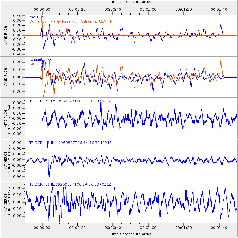
DGR Domenigoni Valley Reservior, California, USA - Earthquake Result Viewer
*The percent match for this event was below the threshold and hence no stack was calculated.
| Earthquake location: |
South Of Fiji Islands |
| Earthquake latitude/longitude: |
-22.6/-179.8 |
| Earthquake time(UTC): |
1996/08/27 (240) 06:24:07 GMT |
| Earthquake Depth: |
575 km |
| Earthquake Magnitude: |
5.6 MB, 6.0 UNKNOWN, 5.5 MB |
| Earthquake Catalog/Contributor: |
WHDF/NEIC |
|
| Network: |
TS TERRAscope (Southern California Seismic Network) |
| Station: |
DGR Domenigoni Valley Reservior, California, USA |
| Lat/Lon: |
33.65 N/117.01 W |
| Elevation: |
700 m |
|
| Distance: |
81.8 deg |
| Az: |
48.539 deg |
| Baz: |
236.141 deg |
| Ray Param: |
$rayparam |
*The percent match for this event was below the threshold and hence was not used in the summary stack. |
|
| Radial Match: |
59.285927 % |
| Radial Bump: |
400 |
| Transverse Match: |
69.5583 % |
| Transverse Bump: |
400 |
| SOD ConfigId: |
4480 |
| Insert Time: |
2010-02-26 14:10:57.418 +0000 |
| GWidth: |
2.5 |
| Max Bumps: |
400 |
| Tol: |
0.001 |
|
Signal To Noise
| Channel | StoN | STA | LTA |
| TS:DGR: :BHN:19960827T06:34:56.334021Z | 4.9620266 | 3.919668E-7 | 7.899328E-8 |
| TS:DGR: :BHE:19960827T06:34:56.334021Z | 1.5926849 | 9.85626E-8 | 6.1884556E-8 |
| TS:DGR: :BHZ:19960827T06:34:56.334021Z | 1.455558 | 1.2739115E-7 | 8.752049E-8 |
| Arrivals |
| Ps | |
| PpPs | |
| PsPs/PpSs | |


