You are here: Home > Network List > TA - USArray Transportable Network (new EarthScope stations) Stations List
> Station M15A Larsen Ranch, Promontory, UT, USA > Earthquake Result Viewer
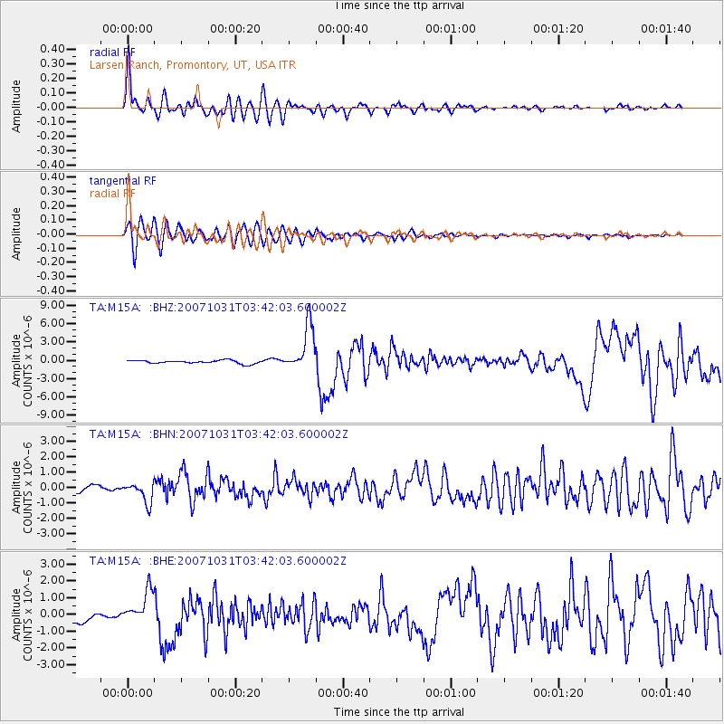
M15A Larsen Ranch, Promontory, UT, USA - Earthquake Result Viewer

| Earthquake location: |
Mariana Islands |
| Earthquake latitude/longitude: |
18.9/145.4 |
| Earthquake time(UTC): |
2007/10/31 (304) 03:30:17 GMT |
| Earthquake Depth: |
223 km |
| Earthquake Magnitude: |
6.2 MB, 7.2 MW, 7.2 MW |
| Earthquake Catalog/Contributor: |
WHDF/NEIC |
|
| Network: |
TA USArray Transportable Network (new EarthScope stations) |
| Station: |
M15A Larsen Ranch, Promontory, UT, USA |
| Lat/Lon: |
41.46 N/112.45 W |
| Elevation: |
1348 m |
|
| Distance: |
86.4 deg |
| Az: |
47.397 deg |
| Baz: |
291.995 deg |
| Ray Param: |
0.04351494 |
| Estimated Moho Depth: |
68.0 km |
| Estimated Crust Vp/Vs: |
1.62 |
| Assumed Crust Vp: |
6.276 km/s |
| Estimated Crust Vs: |
3.868 km/s |
| Estimated Crust Poisson's Ratio: |
0.19 |
|
| Radial Match: |
93.23091 % |
| Radial Bump: |
400 |
| Transverse Match: |
84.74766 % |
| Transverse Bump: |
400 |
| SOD ConfigId: |
2564 |
| Insert Time: |
2010-03-06 21:38:24.022 +0000 |
| GWidth: |
2.5 |
| Max Bumps: |
400 |
| Tol: |
0.001 |
|
Signal To Noise
| Channel | StoN | STA | LTA |
| TA:M15A: :BHN:20071031T03:42:03.600002Z | 3.0409575 | 6.622134E-7 | 2.1776478E-7 |
| TA:M15A: :BHE:20071031T03:42:03.600002Z | 4.7996383 | 1.0301253E-6 | 2.146256E-7 |
| TA:M15A: :BHZ:20071031T03:42:03.600002Z | 14.446325 | 3.851227E-6 | 2.665887E-7 |
| Arrivals |
| Ps | 6.9 SECOND |
| PpPs | 28 SECOND |
| PsPs/PpSs | 35 SECOND |


