You are here: Home > Network List > TA - USArray Transportable Network (new EarthScope stations) Stations List
> Station M15A Larsen Ranch, Promontory, UT, USA > Earthquake Result Viewer
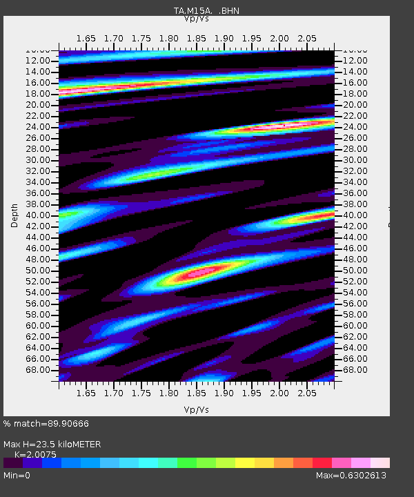
M15A Larsen Ranch, Promontory, UT, USA - Earthquake Result Viewer
| Earthquake location: |
South Of Mariana Islands |
| Earthquake latitude/longitude: |
10.5/145.7 |
| Earthquake time(UTC): |
2007/09/30 (273) 02:08:30 GMT |
| Earthquake Depth: |
14 km |
| Earthquake Magnitude: |
6.4 MB, 7.1 MS, 6.9 MW, 6.9 MW |
| Earthquake Catalog/Contributor: |
WHDF/NEIC |
|
| Network: |
TA USArray Transportable Network (new EarthScope stations) |
| Station: |
M15A Larsen Ranch, Promontory, UT, USA |
| Lat/Lon: |
41.46 N/112.45 W |
| Elevation: |
1348 m |
|
| Distance: |
91.9 deg |
| Az: |
47.392 deg |
| Baz: |
285.587 deg |
| Ray Param: |
0.04154234 |
| Estimated Moho Depth: |
23.5 km |
| Estimated Crust Vp/Vs: |
2.01 |
| Assumed Crust Vp: |
6.276 km/s |
| Estimated Crust Vs: |
3.126 km/s |
| Estimated Crust Poisson's Ratio: |
0.33 |
|
| Radial Match: |
89.90666 % |
| Radial Bump: |
400 |
| Transverse Match: |
85.085495 % |
| Transverse Bump: |
400 |
| SOD ConfigId: |
2564 |
| Insert Time: |
2010-03-06 21:38:26.447 +0000 |
| GWidth: |
2.5 |
| Max Bumps: |
400 |
| Tol: |
0.001 |
|

Signal To Noise
| Channel | StoN | STA | LTA |
| TA:M15A: :BHN:20070930T02:21:06.200029Z | 1.0730267 | 9.5606865E-8 | 8.9100176E-8 |
| TA:M15A: :BHE:20070930T02:21:06.200029Z | 1.7572645 | 1.191444E-7 | 6.780106E-8 |
| TA:M15A: :BHZ:20070930T02:21:06.200029Z | 4.057087 | 4.0731268E-7 | 1.00395354E-7 |
| Arrivals |
| Ps | 3.8 SECOND |
| PpPs | 11 SECOND |
| PsPs/PpSs | 15 SECOND |


