You are here: Home > Network List > TA - USArray Transportable Network (new EarthScope stations) Stations List
> Station M15A Larsen Ranch, Promontory, UT, USA > Earthquake Result Viewer
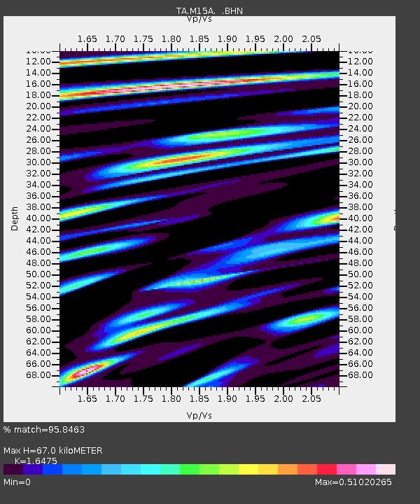
M15A Larsen Ranch, Promontory, UT, USA - Earthquake Result Viewer
| Earthquake location: |
Volcano Islands, Japan Region |
| Earthquake latitude/longitude: |
22.0/142.7 |
| Earthquake time(UTC): |
2007/09/28 (271) 13:38:59 GMT |
| Earthquake Depth: |
276 km |
| Earthquake Magnitude: |
6.7 MB, 7.4 MW, 7.4 MW |
| Earthquake Catalog/Contributor: |
WHDF/NEIC |
|
| Network: |
TA USArray Transportable Network (new EarthScope stations) |
| Station: |
M15A Larsen Ranch, Promontory, UT, USA |
| Lat/Lon: |
41.46 N/112.45 W |
| Elevation: |
1348 m |
|
| Distance: |
86.2 deg |
| Az: |
46.712 deg |
| Baz: |
295.999 deg |
| Ray Param: |
0.043543503 |
| Estimated Moho Depth: |
67.0 km |
| Estimated Crust Vp/Vs: |
1.65 |
| Assumed Crust Vp: |
6.276 km/s |
| Estimated Crust Vs: |
3.809 km/s |
| Estimated Crust Poisson's Ratio: |
0.21 |
|
| Radial Match: |
95.8463 % |
| Radial Bump: |
400 |
| Transverse Match: |
86.66557 % |
| Transverse Bump: |
400 |
| SOD ConfigId: |
2564 |
| Insert Time: |
2010-03-06 21:38:28.062 +0000 |
| GWidth: |
2.5 |
| Max Bumps: |
400 |
| Tol: |
0.001 |
|

Signal To Noise
| Channel | StoN | STA | LTA |
| TA:M15A: :BHN:20070928T13:50:38.648022Z | 24.703377 | 1.7830633E-6 | 7.217893E-8 |
| TA:M15A: :BHE:20070928T13:50:38.648022Z | 33.622437 | 3.4864886E-6 | 1.0369529E-7 |
| TA:M15A: :BHZ:20070928T13:50:38.648022Z | 99.62968 | 1.2156776E-5 | 1.2201963E-7 |
| Arrivals |
| Ps | 7.1 SECOND |
| PpPs | 28 SECOND |
| PsPs/PpSs | 35 SECOND |


