You are here: Home > Network List > TA - USArray Transportable Network (new EarthScope stations) Stations List
> Station M15A Larsen Ranch, Promontory, UT, USA > Earthquake Result Viewer
M15A Larsen Ranch, Promontory, UT, USA - Earthquake Result Viewer

| Earthquake location: |
Komandorskiye Ostrova Region |
| Earthquake latitude/longitude: |
53.6/169.7 |
| Earthquake time(UTC): |
2007/07/29 (210) 04:54:36 GMT |
| Earthquake Depth: |
26 km |
| Earthquake Magnitude: |
6.0 MB, 5.5 MS, 5.9 MW, 5.8 MW |
| Earthquake Catalog/Contributor: |
WHDF/NEIC |
|
| Network: |
TA USArray Transportable Network (new EarthScope stations) |
| Station: |
M15A Larsen Ranch, Promontory, UT, USA |
| Lat/Lon: |
41.46 N/112.45 W |
| Elevation: |
1348 m |
|
| Distance: |
51.4 deg |
| Az: |
70.12 deg |
| Baz: |
311.839 deg |
| Ray Param: |
0.067410946 |
| Estimated Moho Depth: |
37.0 km |
| Estimated Crust Vp/Vs: |
1.62 |
| Assumed Crust Vp: |
6.276 km/s |
| Estimated Crust Vs: |
3.874 km/s |
| Estimated Crust Poisson's Ratio: |
0.19 |
|
| Radial Match: |
84.58787 % |
| Radial Bump: |
400 |
| Transverse Match: |
77.11502 % |
| Transverse Bump: |
400 |
| SOD ConfigId: |
2564 |
| Insert Time: |
2010-03-06 21:38:49.079 +0000 |
| GWidth: |
2.5 |
| Max Bumps: |
400 |
| Tol: |
0.001 |
|
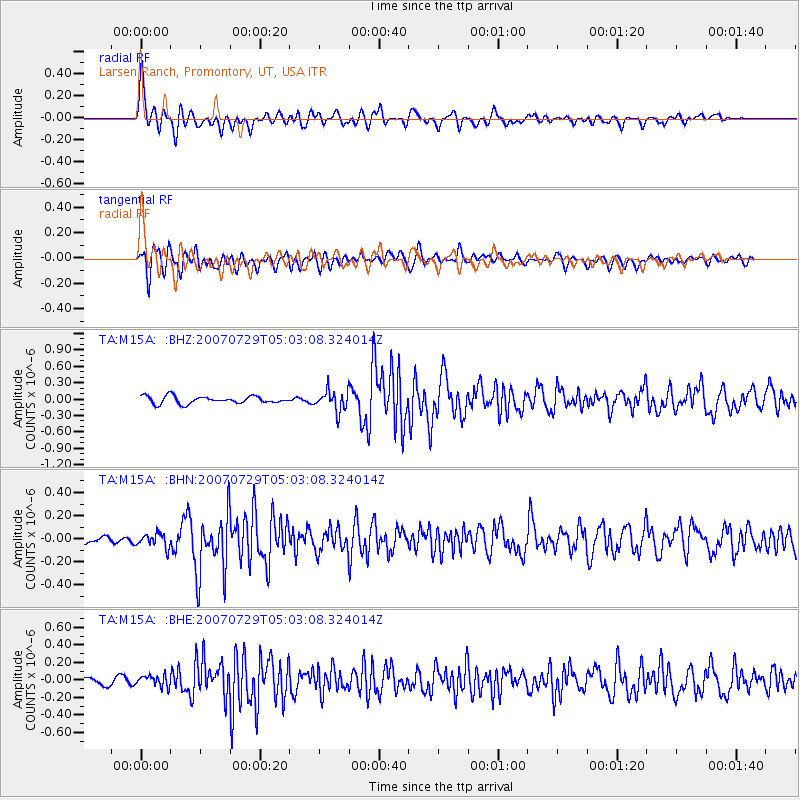
Signal To Noise
| Channel | StoN | STA | LTA |
| TA:M15A: :BHN:20070729T05:03:08.324014Z | 1.8771186 | 6.120463E-8 | 3.260563E-8 |
| TA:M15A: :BHE:20070729T05:03:08.324014Z | 1.4664334 | 6.814057E-8 | 4.6466873E-8 |
| TA:M15A: :BHZ:20070729T05:03:08.324014Z | 2.7975836 | 1.8727214E-7 | 6.694067E-8 |
| Arrivals |
| Ps | 3.9 SECOND |
| PpPs | 15 SECOND |
| PsPs/PpSs | 18 SECOND |


