You are here: Home > Network List > TA - USArray Transportable Network (new EarthScope stations) Stations List
> Station M15A Larsen Ranch, Promontory, UT, USA > Earthquake Result Viewer
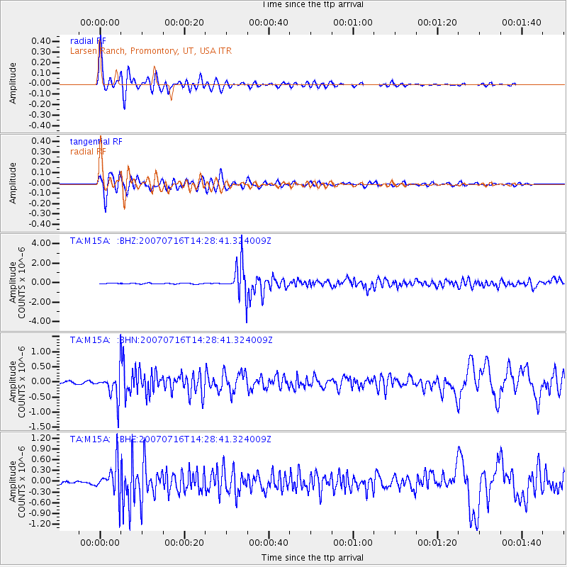
M15A Larsen Ranch, Promontory, UT, USA - Earthquake Result Viewer

| Earthquake location: |
Sea Of Japan |
| Earthquake latitude/longitude: |
36.8/134.9 |
| Earthquake time(UTC): |
2007/07/16 (197) 14:17:37 GMT |
| Earthquake Depth: |
350 km |
| Earthquake Magnitude: |
6.2 MB, 6.8 MW, 6.8 MW |
| Earthquake Catalog/Contributor: |
WHDF/NEIC |
|
| Network: |
TA USArray Transportable Network (new EarthScope stations) |
| Station: |
M15A Larsen Ranch, Promontory, UT, USA |
| Lat/Lon: |
41.46 N/112.45 W |
| Elevation: |
1348 m |
|
| Distance: |
80.8 deg |
| Az: |
44.627 deg |
| Baz: |
311.397 deg |
| Ray Param: |
0.047111053 |
| Estimated Moho Depth: |
56.0 km |
| Estimated Crust Vp/Vs: |
1.76 |
| Assumed Crust Vp: |
6.276 km/s |
| Estimated Crust Vs: |
3.571 km/s |
| Estimated Crust Poisson's Ratio: |
0.26 |
|
| Radial Match: |
93.20726 % |
| Radial Bump: |
400 |
| Transverse Match: |
80.58852 % |
| Transverse Bump: |
400 |
| SOD ConfigId: |
2564 |
| Insert Time: |
2010-03-06 21:38:52.839 +0000 |
| GWidth: |
2.5 |
| Max Bumps: |
400 |
| Tol: |
0.001 |
|
Signal To Noise
| Channel | StoN | STA | LTA |
| TA:M15A: :BHN:20070716T14:28:41.324009Z | 14.8971195 | 4.6298413E-7 | 3.107877E-8 |
| TA:M15A: :BHE:20070716T14:28:41.324009Z | 12.102785 | 4.5367645E-7 | 3.7485293E-8 |
| TA:M15A: :BHZ:20070716T14:28:41.324009Z | 38.895027 | 1.6730614E-6 | 4.301479E-8 |
| Arrivals |
| Ps | 6.9 SECOND |
| PpPs | 24 SECOND |
| PsPs/PpSs | 31 SECOND |


