You are here: Home > Network List > TA - USArray Transportable Network (new EarthScope stations) Stations List
> Station M15A Larsen Ranch, Promontory, UT, USA > Earthquake Result Viewer
M15A Larsen Ranch, Promontory, UT, USA - Earthquake Result Viewer
| Earthquake location: |
Kamchatka Peninsula, Russia |
| Earthquake latitude/longitude: |
52.1/157.3 |
| Earthquake time(UTC): |
2007/05/30 (150) 20:22:12 GMT |
| Earthquake Depth: |
116 km |
| Earthquake Magnitude: |
6.4 MB, 6.4 MW, 6.4 MW |
| Earthquake Catalog/Contributor: |
WHDF/NEIC |
|
| Network: |
TA USArray Transportable Network (new EarthScope stations) |
| Station: |
M15A Larsen Ranch, Promontory, UT, USA |
| Lat/Lon: |
41.46 N/112.45 W |
| Elevation: |
1348 m |
|
| Distance: |
58.8 deg |
| Az: |
61.431 deg |
| Baz: |
313.928 deg |
| Ray Param: |
0.062231094 |
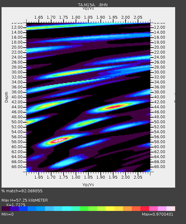
| Estimated Moho Depth: |
57.25 km |
| Estimated Crust Vp/Vs: |
1.73 |
| Assumed Crust Vp: |
6.276 km/s |
| Estimated Crust Vs: |
3.633 km/s |
| Estimated Crust Poisson's Ratio: |
0.25 |
|
| Radial Match: |
92.069855 % |
| Radial Bump: |
400 |
| Transverse Match: |
90.84683 % |
| Transverse Bump: |
400 |
| SOD ConfigId: |
2564 |
| Insert Time: |
2010-03-06 21:39:15.365 +0000 |
| GWidth: |
2.5 |
| Max Bumps: |
400 |
| Tol: |
0.001 |
|
Signal To Noise
| Channel | StoN | STA | LTA |
| TA:M15A: :BHN:20070530T20:31:28.425015Z | 18.226854 | 1.4959099E-6 | 8.207175E-8 |
| TA:M15A: :BHE:20070530T20:31:28.425015Z | 12.276386 | 1.0673198E-6 | 8.694088E-8 |
| TA:M15A: :BHZ:20070530T20:31:28.425015Z | 70.39511 | 4.102274E-6 | 5.827498E-8 |
| Arrivals |
| Ps | 7.0 SECOND |
| PpPs | 24 SECOND |
| PsPs/PpSs | 31 SECOND |


