You are here: Home > Network List > TA - USArray Transportable Network (new EarthScope stations) Stations List
> Station C18K Utukok River, AK, USA > Earthquake Result Viewer
C18K Utukok River, AK, USA - Earthquake Result Viewer
| Earthquake location: |
Samar, Philippines |
| Earthquake latitude/longitude: |
11.8/125.2 |
| Earthquake time(UTC): |
2019/04/23 (113) 05:37:52 GMT |
| Earthquake Depth: |
54 km |
| Earthquake Magnitude: |
6.4 Mww |
| Earthquake Catalog/Contributor: |
NEIC PDE/us |
|
| Network: |
TA USArray Transportable Network (new EarthScope stations) |
| Station: |
C18K Utukok River, AK, USA |
| Lat/Lon: |
68.65 N/161.19 W |
| Elevation: |
845 m |
|
| Distance: |
73.1 deg |
| Az: |
21.545 deg |
| Baz: |
259.02 deg |
| Ray Param: |
0.053128365 |
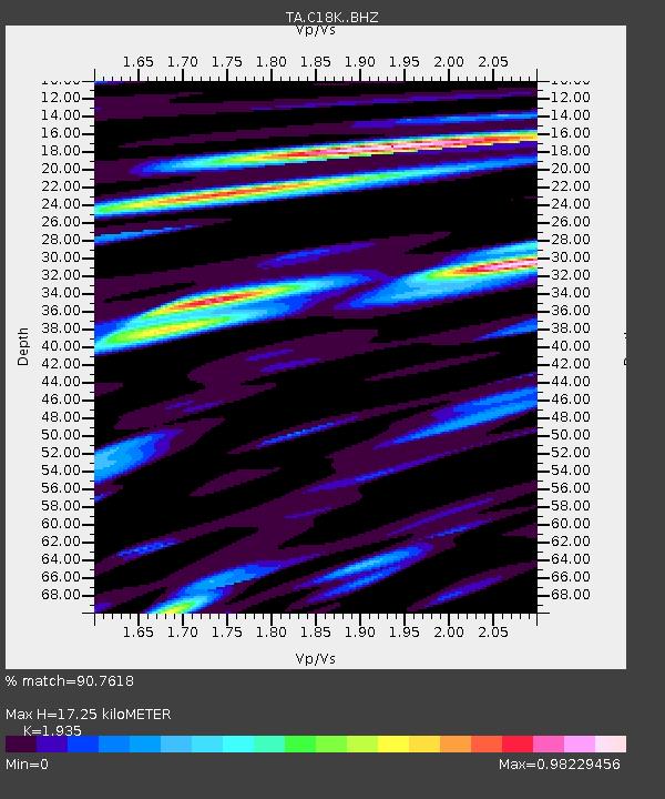
| Estimated Moho Depth: |
17.25 km |
| Estimated Crust Vp/Vs: |
1.93 |
| Assumed Crust Vp: |
5.906 km/s |
| Estimated Crust Vs: |
3.052 km/s |
| Estimated Crust Poisson's Ratio: |
0.32 |
|
| Radial Match: |
90.7618 % |
| Radial Bump: |
400 |
| Transverse Match: |
86.13549 % |
| Transverse Bump: |
400 |
| SOD ConfigId: |
18252611 |
| Insert Time: |
2019-05-07 05:42:12.302 +0000 |
| GWidth: |
2.5 |
| Max Bumps: |
400 |
| Tol: |
0.001 |
|

Signal To Noise
| Channel | StoN | STA | LTA |
| TA:C18K: :BHZ:20190423T05:48:46.575008Z | 39.56834 | 2.451677E-6 | 6.196057E-8 |
| TA:C18K: :BHN:20190423T05:48:46.575008Z | 4.6835823 | 3.894211E-7 | 8.3146E-8 |
| TA:C18K: :BHE:20190423T05:48:46.575008Z | 10.332781 | 7.536309E-7 | 7.2935926E-8 |
| Arrivals |
| Ps | 2.8 SECOND |
| PpPs | 8.3 SECOND |
| PsPs/PpSs | 11 SECOND |


