You are here: Home > Network List > TA - USArray Transportable Network (new EarthScope stations) Stations List
> Station M15A Larsen Ranch, Promontory, UT, USA > Earthquake Result Viewer
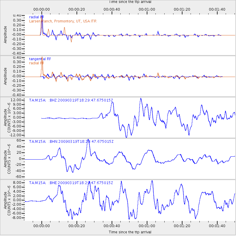
M15A Larsen Ranch, Promontory, UT, USA - Earthquake Result Viewer

| Earthquake location: |
Tonga Islands Region |
| Earthquake latitude/longitude: |
-23.0/-174.7 |
| Earthquake time(UTC): |
2009/03/19 (078) 18:17:40 GMT |
| Earthquake Depth: |
34 km |
| Earthquake Magnitude: |
7.0 MB, 7.6 MS, 7.6 MW, 7.6 MW |
| Earthquake Catalog/Contributor: |
WHDF/NEIC |
|
| Network: |
TA USArray Transportable Network (new EarthScope stations) |
| Station: |
M15A Larsen Ranch, Promontory, UT, USA |
| Lat/Lon: |
41.46 N/112.45 W |
| Elevation: |
1348 m |
|
| Distance: |
86.2 deg |
| Az: |
41.787 deg |
| Baz: |
234.754 deg |
| Ray Param: |
0.04416571 |
| Estimated Moho Depth: |
50.0 km |
| Estimated Crust Vp/Vs: |
1.78 |
| Assumed Crust Vp: |
6.276 km/s |
| Estimated Crust Vs: |
3.526 km/s |
| Estimated Crust Poisson's Ratio: |
0.27 |
|
| Radial Match: |
98.30449 % |
| Radial Bump: |
315 |
| Transverse Match: |
89.96597 % |
| Transverse Bump: |
400 |
| SOD ConfigId: |
2658 |
| Insert Time: |
2010-03-06 21:39:32.079 +0000 |
| GWidth: |
2.5 |
| Max Bumps: |
400 |
| Tol: |
0.001 |
|
Signal To Noise
| Channel | StoN | STA | LTA |
| TA:M15A: :BHN:20090319T18:29:47.675015Z | 20.822557 | 5.812404E-6 | 2.7913978E-7 |
| TA:M15A: :BHE:20090319T18:29:47.675015Z | 8.175169 | 1.045043E-6 | 1.2783134E-7 |
| TA:M15A: :BHZ:20090319T18:29:47.675015Z | 10.15532 | 1.5456001E-6 | 1.521961E-7 |
| Arrivals |
| Ps | 6.4 SECOND |
| PpPs | 22 SECOND |
| PsPs/PpSs | 28 SECOND |


