You are here: Home > Network List > TA - USArray Transportable Network (new EarthScope stations) Stations List
> Station M15A Larsen Ranch, Promontory, UT, USA > Earthquake Result Viewer
M15A Larsen Ranch, Promontory, UT, USA - Earthquake Result Viewer
| Earthquake location: |
South Of Mariana Islands |
| Earthquake latitude/longitude: |
12.5/143.2 |
| Earthquake time(UTC): |
2008/05/09 (130) 21:51:29 GMT |
| Earthquake Depth: |
76 km |
| Earthquake Magnitude: |
6.1 MB, 6.7 MW, 6.7 MW |
| Earthquake Catalog/Contributor: |
WHDF/NEIC |
|
| Network: |
TA USArray Transportable Network (new EarthScope stations) |
| Station: |
M15A Larsen Ranch, Promontory, UT, USA |
| Lat/Lon: |
41.46 N/112.45 W |
| Elevation: |
1348 m |
|
| Distance: |
92.3 deg |
| Az: |
46.773 deg |
| Baz: |
288.783 deg |
| Ray Param: |
0.041447558 |
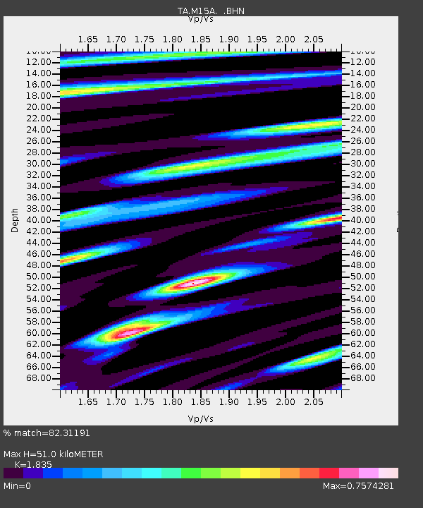
| Estimated Moho Depth: |
51.0 km |
| Estimated Crust Vp/Vs: |
1.84 |
| Assumed Crust Vp: |
6.276 km/s |
| Estimated Crust Vs: |
3.42 km/s |
| Estimated Crust Poisson's Ratio: |
0.29 |
|
| Radial Match: |
82.31191 % |
| Radial Bump: |
400 |
| Transverse Match: |
77.72795 % |
| Transverse Bump: |
400 |
| SOD ConfigId: |
2504 |
| Insert Time: |
2010-03-06 21:39:43.030 +0000 |
| GWidth: |
2.5 |
| Max Bumps: |
400 |
| Tol: |
0.001 |
|

Signal To Noise
| Channel | StoN | STA | LTA |
| TA:M15A: :BHN:20080509T22:04:00.224019Z | 6.8689723 | 3.9870486E-7 | 5.8044325E-8 |
| TA:M15A: :BHE:20080509T22:04:00.224019Z | 0.86593556 | 6.0849246E-8 | 7.026995E-8 |
| TA:M15A: :BHZ:20080509T22:04:00.224019Z | 2.348971 | 1.4836783E-7 | 6.316291E-8 |
| Arrivals |
| Ps | 6.9 SECOND |
| PpPs | 23 SECOND |
| PsPs/PpSs | 30 SECOND |


