You are here: Home > Network List > TA - USArray Transportable Network (new EarthScope stations) Stations List
> Station F21K Alatna River, AK, USA > Earthquake Result Viewer
F21K Alatna River, AK, USA - Earthquake Result Viewer
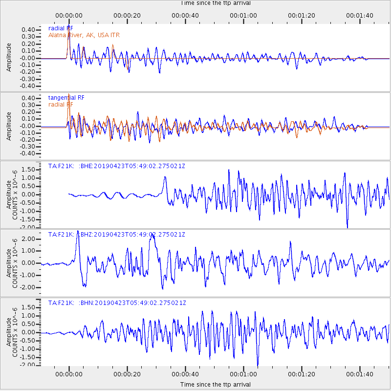
| Earthquake location: |
Samar, Philippines |
| Earthquake latitude/longitude: |
11.8/125.2 |
| Earthquake time(UTC): |
2019/04/23 (113) 05:37:52 GMT |
| Earthquake Depth: |
54 km |
| Earthquake Magnitude: |
6.4 Mww |
| Earthquake Catalog/Contributor: |
NEIC PDE/us |
|
| Network: |
TA USArray Transportable Network (new EarthScope stations) |
| Station: |
F21K Alatna River, AK, USA |
| Lat/Lon: |
67.22 N/153.48 W |
| Elevation: |
597 m |
|
| Distance: |
75.8 deg |
| Az: |
23.394 deg |
| Baz: |
266.658 deg |
| Ray Param: |
0.05132046 |
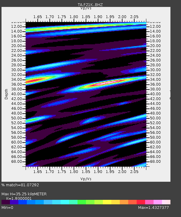
| Estimated Moho Depth: |
35.25 km |
| Estimated Crust Vp/Vs: |
1.93 |
| Assumed Crust Vp: |
6.455 km/s |
| Estimated Crust Vs: |
3.345 km/s |
| Estimated Crust Poisson's Ratio: |
0.32 |
|
| Radial Match: |
81.07292 % |
| Radial Bump: |
400 |
| Transverse Match: |
74.17419 % |
| Transverse Bump: |
400 |
| SOD ConfigId: |
18252611 |
| Insert Time: |
2019-05-07 05:42:33.007 +0000 |
| GWidth: |
2.5 |
| Max Bumps: |
400 |
| Tol: |
0.001 |
|
Signal To Noise
| Channel | StoN | STA | LTA |
| TA:F21K: :BHZ:20190423T05:49:02.275021Z | 10.640817 | 1.136107E-6 | 1.0676878E-7 |
| TA:F21K: :BHN:20190423T05:49:02.275021Z | 1.8240561 | 8.9926424E-8 | 4.930025E-8 |
| TA:F21K: :BHE:20190423T05:49:02.275021Z | 4.9552116 | 4.7557242E-7 | 9.5974194E-8 |
| Arrivals |
| Ps | 5.2 SECOND |
| PpPs | 16 SECOND |
| PsPs/PpSs | 21 SECOND |


