You are here: Home > Network List > TA - USArray Transportable Network (new EarthScope stations) Stations List
> Station F26K Sheenjek River, AK, USA > Earthquake Result Viewer
F26K Sheenjek River, AK, USA - Earthquake Result Viewer
| Earthquake location: |
Samar, Philippines |
| Earthquake latitude/longitude: |
11.8/125.2 |
| Earthquake time(UTC): |
2019/04/23 (113) 05:37:52 GMT |
| Earthquake Depth: |
54 km |
| Earthquake Magnitude: |
6.4 Mww |
| Earthquake Catalog/Contributor: |
NEIC PDE/us |
|
| Network: |
TA USArray Transportable Network (new EarthScope stations) |
| Station: |
F26K Sheenjek River, AK, USA |
| Lat/Lon: |
67.69 N/144.15 W |
| Elevation: |
683 m |
|
| Distance: |
79.4 deg |
| Az: |
22.852 deg |
| Baz: |
275.16 deg |
| Ray Param: |
0.04889483 |
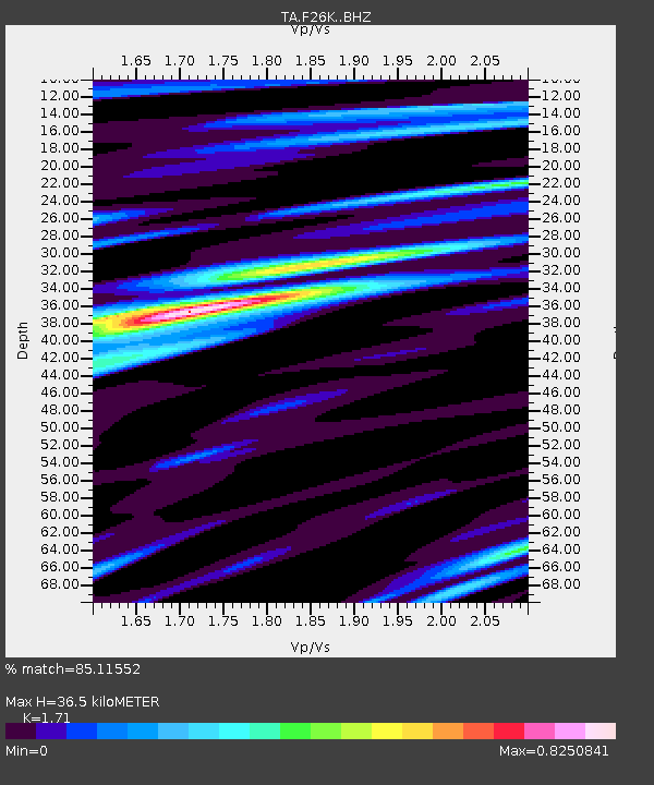
| Estimated Moho Depth: |
36.5 km |
| Estimated Crust Vp/Vs: |
1.71 |
| Assumed Crust Vp: |
6.522 km/s |
| Estimated Crust Vs: |
3.814 km/s |
| Estimated Crust Poisson's Ratio: |
0.24 |
|
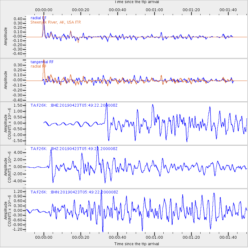
| Radial Match: |
85.11552 % |
| Radial Bump: |
400 |
| Transverse Match: |
85.879364 % |
| Transverse Bump: |
400 |
| SOD ConfigId: |
18252611 |
| Insert Time: |
2019-05-07 05:42:34.855 +0000 |
| GWidth: |
2.5 |
| Max Bumps: |
400 |
| Tol: |
0.001 |
|
Signal To Noise
| Channel | StoN | STA | LTA |
| TA:F26K: :BHZ:20190423T05:49:22.200008Z | 13.626356 | 1.8433675E-6 | 1.3527956E-7 |
| TA:F26K: :BHN:20190423T05:49:22.200008Z | 1.5539317 | 1.5687414E-7 | 1.00953045E-7 |
| TA:F26K: :BHE:20190423T05:49:22.200008Z | 6.3908772 | 6.43746E-7 | 1.0072889E-7 |
| Arrivals |
| Ps | 4.1 SECOND |
| PpPs | 15 SECOND |
| PsPs/PpSs | 19 SECOND |


