You are here: Home > Network List > TA - USArray Transportable Network (new EarthScope stations) Stations List
> Station G23K Bananza Creek, AK, USA > Earthquake Result Viewer
G23K Bananza Creek, AK, USA - Earthquake Result Viewer

| Earthquake location: |
Samar, Philippines |
| Earthquake latitude/longitude: |
11.8/125.2 |
| Earthquake time(UTC): |
2019/04/23 (113) 05:37:52 GMT |
| Earthquake Depth: |
54 km |
| Earthquake Magnitude: |
6.4 Mww |
| Earthquake Catalog/Contributor: |
NEIC PDE/us |
|
| Network: |
TA USArray Transportable Network (new EarthScope stations) |
| Station: |
G23K Bananza Creek, AK, USA |
| Lat/Lon: |
66.71 N/150.02 W |
| Elevation: |
746 m |
|
| Distance: |
77.1 deg |
| Az: |
23.964 deg |
| Baz: |
269.972 deg |
| Ray Param: |
0.05041881 |
| Estimated Moho Depth: |
41.25 km |
| Estimated Crust Vp/Vs: |
1.60 |
| Assumed Crust Vp: |
6.577 km/s |
| Estimated Crust Vs: |
4.11 km/s |
| Estimated Crust Poisson's Ratio: |
0.18 |
|
| Radial Match: |
95.73034 % |
| Radial Bump: |
384 |
| Transverse Match: |
89.60591 % |
| Transverse Bump: |
400 |
| SOD ConfigId: |
18252611 |
| Insert Time: |
2019-05-07 05:42:41.071 +0000 |
| GWidth: |
2.5 |
| Max Bumps: |
400 |
| Tol: |
0.001 |
|
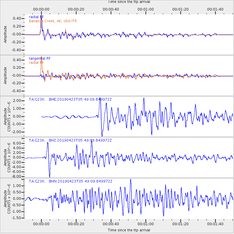
Signal To Noise
| Channel | StoN | STA | LTA |
| TA:G23K: :BHZ:20190423T05:49:09.849972Z | 24.97782 | 2.9945281E-6 | 1.198875E-7 |
| TA:G23K: :BHN:20190423T05:49:09.849972Z | 1.2818452 | 8.014886E-8 | 6.2526155E-8 |
| TA:G23K: :BHE:20190423T05:49:09.849972Z | 9.67611 | 9.683213E-7 | 1.000734E-7 |
| Arrivals |
| Ps | 3.9 SECOND |
| PpPs | 16 SECOND |
| PsPs/PpSs | 20 SECOND |


