You are here: Home > Network List > TA - USArray Transportable Network (new EarthScope stations) Stations List
> Station I17K Unalakleet, AK, USA > Earthquake Result Viewer
I17K Unalakleet, AK, USA - Earthquake Result Viewer
| Earthquake location: |
Samar, Philippines |
| Earthquake latitude/longitude: |
11.8/125.2 |
| Earthquake time(UTC): |
2019/04/23 (113) 05:37:52 GMT |
| Earthquake Depth: |
54 km |
| Earthquake Magnitude: |
6.4 Mww |
| Earthquake Catalog/Contributor: |
NEIC PDE/us |
|
| Network: |
TA USArray Transportable Network (new EarthScope stations) |
| Station: |
I17K Unalakleet, AK, USA |
| Lat/Lon: |
63.89 N/160.70 W |
| Elevation: |
105 m |
|
| Distance: |
72.5 deg |
| Az: |
26.514 deg |
| Baz: |
260.95 deg |
| Ray Param: |
0.053542327 |
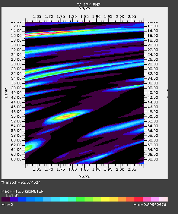
| Estimated Moho Depth: |
15.5 km |
| Estimated Crust Vp/Vs: |
1.61 |
| Assumed Crust Vp: |
6.276 km/s |
| Estimated Crust Vs: |
3.898 km/s |
| Estimated Crust Poisson's Ratio: |
0.19 |
|
| Radial Match: |
95.074524 % |
| Radial Bump: |
400 |
| Transverse Match: |
91.50906 % |
| Transverse Bump: |
400 |
| SOD ConfigId: |
18252611 |
| Insert Time: |
2019-05-07 05:42:52.375 +0000 |
| GWidth: |
2.5 |
| Max Bumps: |
400 |
| Tol: |
0.001 |
|

Signal To Noise
| Channel | StoN | STA | LTA |
| TA:I17K: :BHZ:20190423T05:48:42.849972Z | 35.761494 | 2.810874E-6 | 7.8600586E-8 |
| TA:I17K: :BHN:20190423T05:48:42.849972Z | 3.601618 | 3.1173943E-7 | 8.655538E-8 |
| TA:I17K: :BHE:20190423T05:48:42.849972Z | 7.044008 | 9.766147E-7 | 1.3864477E-7 |
| Arrivals |
| Ps | 1.6 SECOND |
| PpPs | 6.2 SECOND |
| PsPs/PpSs | 7.8 SECOND |


