You are here: Home > Network List > TA - USArray Transportable Network (new EarthScope stations) Stations List
> Station J25K Salcha River, AK, USA > Earthquake Result Viewer
J25K Salcha River, AK, USA - Earthquake Result Viewer
| Earthquake location: |
Samar, Philippines |
| Earthquake latitude/longitude: |
11.8/125.2 |
| Earthquake time(UTC): |
2019/04/23 (113) 05:37:52 GMT |
| Earthquake Depth: |
54 km |
| Earthquake Magnitude: |
6.4 Mww |
| Earthquake Catalog/Contributor: |
NEIC PDE/us |
|
| Network: |
TA USArray Transportable Network (new EarthScope stations) |
| Station: |
J25K Salcha River, AK, USA |
| Lat/Lon: |
64.61 N/145.37 W |
| Elevation: |
949 m |
|
| Distance: |
79.2 deg |
| Az: |
26.034 deg |
| Baz: |
274.634 deg |
| Ray Param: |
0.049053337 |
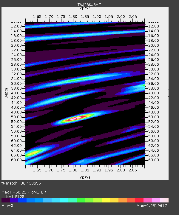
| Estimated Moho Depth: |
50.25 km |
| Estimated Crust Vp/Vs: |
1.81 |
| Assumed Crust Vp: |
6.566 km/s |
| Estimated Crust Vs: |
3.623 km/s |
| Estimated Crust Poisson's Ratio: |
0.28 |
|
| Radial Match: |
86.433655 % |
| Radial Bump: |
400 |
| Transverse Match: |
68.44488 % |
| Transverse Bump: |
400 |
| SOD ConfigId: |
18252611 |
| Insert Time: |
2019-05-07 05:43:01.430 +0000 |
| GWidth: |
2.5 |
| Max Bumps: |
400 |
| Tol: |
0.001 |
|
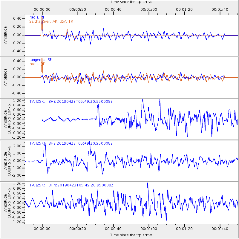
Signal To Noise
| Channel | StoN | STA | LTA |
| TA:J25K: :BHZ:20190423T05:49:20.950008Z | 10.421161 | 1.1564285E-6 | 1.1096926E-7 |
| TA:J25K: :BHN:20190423T05:49:20.950008Z | 1.2009366 | 1.6503327E-7 | 1.3742047E-7 |
| TA:J25K: :BHE:20190423T05:49:20.950008Z | 6.1824975 | 4.1394108E-7 | 6.69537E-8 |
| Arrivals |
| Ps | 6.4 SECOND |
| PpPs | 21 SECOND |
| PsPs/PpSs | 27 SECOND |


