You are here: Home > Network List > US - United States National Seismic Network Stations List
> Station NATX Nacogdoches, Texas, USA > Earthquake Result Viewer
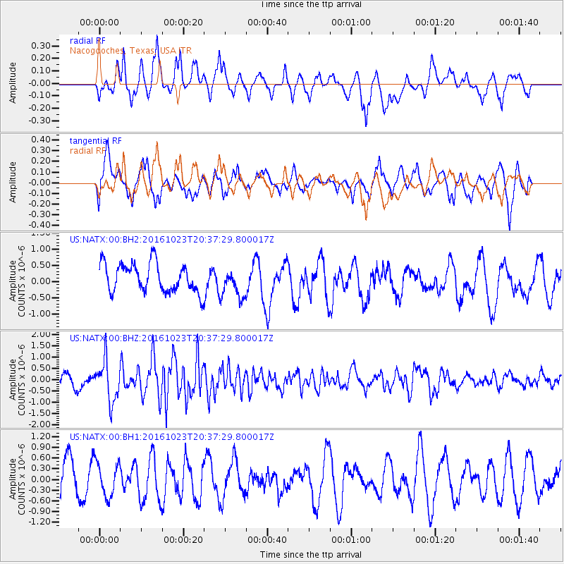
NATX Nacogdoches, Texas, USA - Earthquake Result Viewer
*The percent match for this event was below the threshold and hence no stack was calculated.
| Earthquake location: |
East Of Kuril Islands |
| Earthquake latitude/longitude: |
44.0/148.2 |
| Earthquake time(UTC): |
2016/10/23 (297) 20:25:26 GMT |
| Earthquake Depth: |
30 km |
| Earthquake Magnitude: |
5.8 MB |
| Earthquake Catalog/Contributor: |
NEIC PDE/NEIC COMCAT |
|
| Network: |
US United States National Seismic Network |
| Station: |
NATX Nacogdoches, Texas, USA |
| Lat/Lon: |
31.76 N/94.66 W |
| Elevation: |
168 m |
|
| Distance: |
85.3 deg |
| Az: |
49.493 deg |
| Baz: |
319.884 deg |
| Ray Param: |
$rayparam |
*The percent match for this event was below the threshold and hence was not used in the summary stack. |
|
| Radial Match: |
54.011192 % |
| Radial Bump: |
373 |
| Transverse Match: |
63.52467 % |
| Transverse Bump: |
394 |
| SOD ConfigId: |
1815711 |
| Insert Time: |
2016-11-06 20:29:51.727 +0000 |
| GWidth: |
2.5 |
| Max Bumps: |
400 |
| Tol: |
0.001 |
|
Signal To Noise
| Channel | StoN | STA | LTA |
| US:NATX:00:BHZ:20161023T20:37:29.800017Z | 3.5435739 | 9.2897386E-7 | 2.6215733E-7 |
| US:NATX:00:BH1:20161023T20:37:29.800017Z | 0.7022672 | 4.5856612E-7 | 6.5297957E-7 |
| US:NATX:00:BH2:20161023T20:37:29.800017Z | 1.0409317 | 4.6115414E-7 | 4.4302058E-7 |
| Arrivals |
| Ps | |
| PpPs | |
| PsPs/PpSs | |


