You are here: Home > Network List > TS - TERRAscope (Southern California Seismic Network) Stations List
> Station DGR Domenigoni Valley Reservior, California, USA > Earthquake Result Viewer
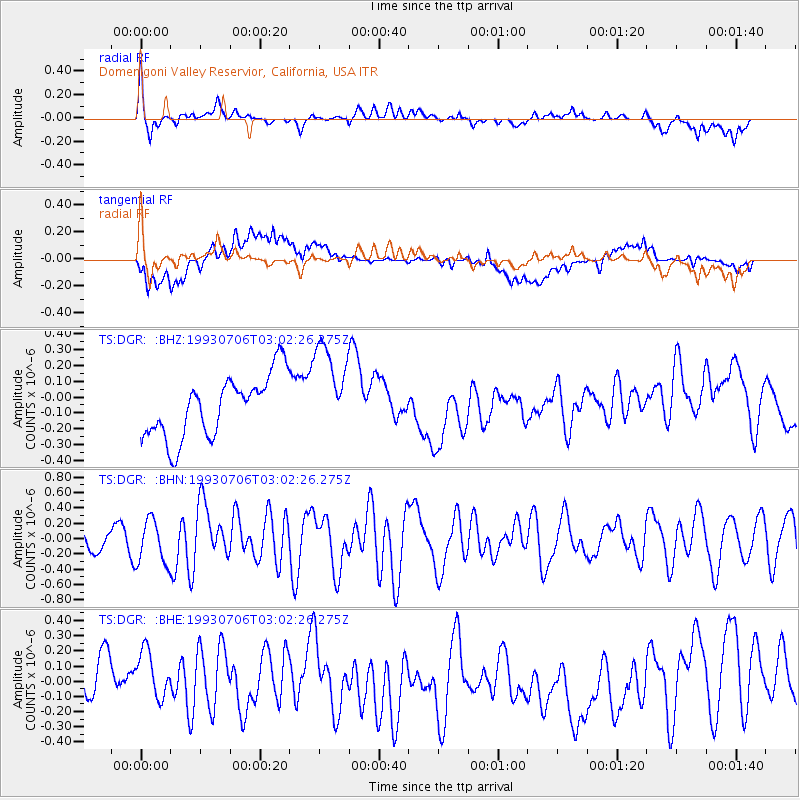
DGR Domenigoni Valley Reservior, California, USA - Earthquake Result Viewer
*The percent match for this event was below the threshold and hence no stack was calculated.
| Earthquake location: |
Easter Island Region |
| Earthquake latitude/longitude: |
-24.6/-111.9 |
| Earthquake time(UTC): |
1993/07/06 (187) 02:53:03 GMT |
| Earthquake Depth: |
10 km |
| Earthquake Magnitude: |
5.5 MB, 6.1 MS, 5.9 UNKNOWN, 6.4 MW |
| Earthquake Catalog/Contributor: |
WHDF/NEIC |
|
| Network: |
TS TERRAscope (Southern California Seismic Network) |
| Station: |
DGR Domenigoni Valley Reservior, California, USA |
| Lat/Lon: |
33.65 N/117.01 W |
| Elevation: |
700 m |
|
| Distance: |
58.1 deg |
| Az: |
354.939 deg |
| Baz: |
174.474 deg |
| Ray Param: |
$rayparam |
*The percent match for this event was below the threshold and hence was not used in the summary stack. |
|
| Radial Match: |
65.82923 % |
| Radial Bump: |
400 |
| Transverse Match: |
58.089035 % |
| Transverse Bump: |
400 |
| SOD ConfigId: |
4480 |
| Insert Time: |
2010-02-26 14:10:58.623 +0000 |
| GWidth: |
2.5 |
| Max Bumps: |
400 |
| Tol: |
0.001 |
|
Signal To Noise
| Channel | StoN | STA | LTA |
| TS:DGR: :BHN:19930706T03:02:26.275Z | 2.024066 | 2.900881E-7 | 1.433195E-7 |
| TS:DGR: :BHE:19930706T03:02:26.275Z | 1.277974 | 1.9686738E-7 | 1.5404646E-7 |
| TS:DGR: :BHZ:19930706T03:02:26.275Z | 1.5357718 | 2.9969837E-7 | 1.9514512E-7 |
| Arrivals |
| Ps | |
| PpPs | |
| PsPs/PpSs | |


